Casalborsetti geodata
Casalborsetti (Emilia-Romagna) is a populated place; located in Italy in Europe/Rome (GMT+2) time zone. With population of 802 people, there are 7635 cities with bigger population in this country. Compared to other cities in Italy, 51.7% of cities are located further ↓South; 59.6% of cities are located further ←West and 99% of cities have higher elevation than Casalborsetti. Note1


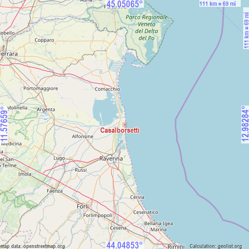
Casalborsetti GPS coordinates[2]
44° 33' 6.3" North, 12° 16' 46.956" East
| Map corner | latitude | longitude |
|---|---|---|
| Upper-left | 45.05065°, | 11.57659° |
| Center: | 44.55175°, | 12.27971° |
| Lower-right: | 44.04853°, | 12.98284° |
| Map W x H: | 111.4×111.4 km | = 69.2×69.2mi |
| max Lat: | 47.04031° ⇑48.3% North |
| Casalborsetti: | 44.55175° |
| min Lat: | ⇓51.7% South 35.50142° |
| min Long | Casalborsetti | max Long |
| 6.69888° | 12.27971° | 18.48682° |
| W 59.6%⇐ | ⇒40.4% E |
Elevation
Elevation of Casalborsetti is 2 m = 7 ft, and this is 304.7 m = 1000 ft below average elevation for this country.
| Max E: |
2085 m = 6841 ft | 99% |
| Avg. | 306.7 m = 1006 ft | |
| Casalborsetti | 2 m = 7 ft | |
Min E: |
-4 m = -13 ft | 1% |
See also: Italy elevation on elevation.city.
Geographical zone
Casalborsetti is located in North temperate zone (between Tropic of Cancer and the Arctic Circle). Distance of this Northern Tropic circle is 2347.8 km =1458.9 mi to South.| Distance of | km | miles | from Casalborsetti |
|---|---|---|---|
| North Pole | 5053.4 | 3140 | to North |
| Arctic Circle | 2447.5 | 1520.8 | to North |
| Tropic Cancer | 2347.8 | 1458.9 | to South |
| Equator | 4953.7 | 3078.1 | to South |


Nearby cities:
15 places around Casalborsetti: (largest is in red/bold)
• Camerlona
17 km =10.6 mi,  226°
226°
• Comacchio
17.7 km =11 mi,  334°
334°
• Lido Adriano
15.2 km =9.4 mi,  172°
172°
• Lido degli Estensi
13 km =8.1 mi,  349°
349°
• Lido di Pomposa-Lido degli Scacchi
17.6 km =10.9 mi, 348°
• Lido di Spina
11.1 km =6.9 mi, 347°
• Marina Romea
4.1 km =2.5 mi,  189°
189°
• Marina di Ravenna
7.3 km =4.5 mi,  179°
179°
• Porto Corsini
6.4 km =4 mi, 180°
• Porto Fuori
16.4 km =10.2 mi, 187°
• Porto Garibaldi
14.8 km =9.2 mi, 346°
• Punta Marina
12.2 km =7.6 mi, 175°
• Ravenna
16.6 km =10.3 mi,  202°
202°
• Sant'Alberto
9.5 km =5.9 mi,  260°
260°
• Savarna-Conventello
14.6 km =9.1 mi,  250°
250°
Sources, notices
• [Note1] Compared only with cities in Italy existing in our database
• [Src1] Map data: © OpenStreetMap contributors (CC-BY-SA)
• [Src2] Other city data from geonames.org with taken over terms of usage.
• [Src3] Geographical zone / Annual Mean Temperature by Robert A. Rohde @ Wikipedia
