Carmignano geodata
Carmignano (Tuscany) is a seat of a third-order administrative division; located in Italy in Europe/Rome (GMT+2) time zone. With population of 1,865 people, there are 4382 cities with bigger population in this country. Compared to other cities in Italy, 56.9% of cities are located further ↑North; 57.1% of cities are located further →East and 54.9% of cities have higher elevation than Carmignano. Note1


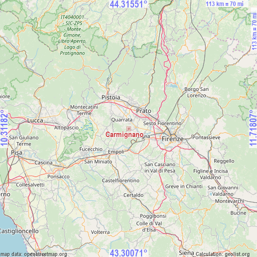
Carmignano GPS coordinates[2]
43° 48' 36.972" North, 11° 0' 53.784" East
| Map corner | latitude | longitude |
|---|---|---|
| Upper-left | 44.31551°, | 10.31182° |
| Center: | 43.81027°, | 11.01494° |
| Lower-right: | 43.30071°, | 11.71807° |
| Map W x H: | 112.8×112.8 km | = 70.1×70.1mi |
| max Lat: | 47.04031° ⇑56.9% North |
| Carmignano: | 43.81027° |
| min Lat: | ⇓43.1% South 35.50142° |
| min Long | Carmignano | max Long |
| 6.69888° | 11.01494° | 18.48682° |
| W 42.9%⇐ | ⇒57.1% E |
Elevation
Elevation of Carmignano is 203 m = 666 ft, and this is 103.7 m = 340 ft below average elevation for this country.
| Max E: |
2085 m = 6841 ft | 54.9% |
| Avg. | 306.7 m = 1006 ft | |
| Carmignano | 203 m = 666 ft | |
Min E: |
-4 m = -13 ft | 45.1% |
See also: Italy elevation on elevation.city.
Geographical zone
Carmignano is located in North temperate zone (between Tropic of Cancer and the Arctic Circle). Distance of this Northern Tropic circle is 2265.3 km =1407.6 mi to South.| Distance of | km | miles | from Carmignano |
|---|---|---|---|
| North Pole | 5135.8 | 3191.2 | to North |
| Arctic Circle | 2529.9 | 1572 | to North |
| Tropic Cancer | 2265.3 | 1407.6 | to South |
| Equator | 4871.2 | 3026.8 | to South |


Nearby cities:
15 places around Carmignano: (largest is in red/bold)
• Capraia e Limite
7.6 km =4.7 mi,  199°
199°
• Caserana
6 km =3.7 mi,  359°
359°
• Casini
5.5 km =3.4 mi,  347°
347°
• Catena
3.6 km =2.2 mi,  2°
2°
• Comeana
4 km =2.5 mi,  118°
118°
• Limite
7.8 km =4.8 mi, 201°
• Poggetto
2.7 km =1.7 mi,  43°
43°
• Poggio A Caiano
3 km =1.9 mi,  82°
82°
• Quarrata
5.1 km =3.2 mi,  325°
325°
• Seano
2.3 km =1.4 mi,  12°
12°
• Serra
1.5 km =0.9 mi, 123°
• Signa
7.3 km =4.5 mi,  104°
104°
• Valenzatico
7.5 km =4.7 mi, 327°
• Vignole-Olmi
6.6 km =4.1 mi,  342°
342°
• Vitolini
5.9 km =3.7 mi,  234°
234°
Sources, notices
• [Note1] Compared only with cities in Italy existing in our database
• [Src1] Map data: © OpenStreetMap contributors (CC-BY-SA)
• [Src2] Other city data from geonames.org with taken over terms of usage.
• [Src3] Geographical zone / Annual Mean Temperature by Robert A. Rohde @ Wikipedia
