Comeana geodata
Comeana (Tuscany) is a populated place; located in Italy in Europe/Rome (GMT+2) time zone. With population of 2,683 people, there are 3328 cities with bigger population in this country. Compared to other cities in Italy, 57.1% of cities are located further ↑North; 56.5% of cities are located further →East and 76.5% of cities have higher elevation than Comeana. Note1


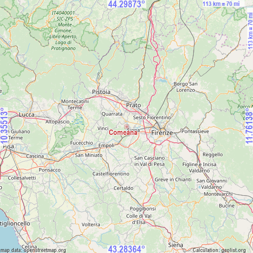
Comeana GPS coordinates[2]
43° 47' 36.024" North, 11° 3' 29.7" East
| Map corner | latitude | longitude |
|---|---|---|
| Upper-left | 44.29873°, | 10.35513° |
| Center: | 43.79334°, | 11.05825° |
| Lower-right: | 43.28364°, | 11.76138° |
| Map W x H: | 112.9×112.9 km | = 70.2×70.2mi |
| max Lat: | 47.04031° ⇑57.1% North |
| Comeana: | 43.79334° |
| min Lat: | ⇓42.9% South 35.50142° |
| min Long | Comeana | max Long |
| 6.69888° | 11.05825° | 18.48682° |
| W 43.5%⇐ | ⇒56.5% E |
Elevation
Elevation of Comeana is 67 m = 220 ft, and this is 239.7 m = 786 ft below average elevation for this country.
| Max E: |
2085 m = 6841 ft | 76.5% |
| Avg. | 306.7 m = 1006 ft | |
| Comeana | 67 m = 220 ft | |
Min E: |
-4 m = -13 ft | 23.5% |
See also: Italy elevation on elevation.city.
Geographical zone
Comeana is located in North temperate zone (between Tropic of Cancer and the Arctic Circle). Distance of this Northern Tropic circle is 2263.4 km =1406.4 mi to South.| Distance of | km | miles | from Comeana |
|---|---|---|---|
| North Pole | 5137.7 | 3192.4 | to North |
| Arctic Circle | 2531.8 | 1573.2 | to North |
| Tropic Cancer | 2263.4 | 1406.4 | to South |
| Equator | 4869.4 | 3025.7 | to South |


Nearby cities:
15 places around Comeana: (largest is in red/bold)
• Campi Bisenzio
6.7 km =4.2 mi,  59°
59°
• Capraia e Limite
8 km =5 mi,  228°
228°
• Carmignano
4 km =2.5 mi,  298°
298°
• Catena
6.4 km =4 mi,  328°
328°
• Lastra a Signa
5.1 km =3.2 mi,  120°
120°
• Malmantile
5.3 km =3.3 mi,  167°
167°
• Montelupo Fiorentino
8.1 km =5 mi,  208°
208°
• Poggetto
4.2 km =2.6 mi,  337°
337°
• Poggio A Caiano
2.3 km =1.4 mi,  347°
347°
• Quattro Strade
6 km =3.7 mi,  162°
162°
• San Donnino
7.1 km =4.4 mi,  88°
88°
• San Mauro
5.4 km =3.4 mi, 89°
• Seano
5.1 km =3.2 mi,  324°
324°
• Serra
2.5 km =1.6 mi, 295°
• Signa
3.6 km =2.2 mi, 88°
Sources, notices
• [Note1] Compared only with cities in Italy existing in our database
• [Src1] Map data: © OpenStreetMap contributors (CC-BY-SA)
• [Src2] Other city data from geonames.org with taken over terms of usage.
• [Src3] Geographical zone / Annual Mean Temperature by Robert A. Rohde @ Wikipedia
