Valenzatico geodata
Valenzatico (Tuscany) is a populated place; located in Italy in Europe/Rome (GMT+2) time zone. With population of 1,901 people, there are 4314 cities with bigger population in this country. Compared to other cities in Italy, 56.1% of cities are located further ↑North; 57.8% of cities are located further →East and 82.2% of cities have higher elevation than Valenzatico. Note1


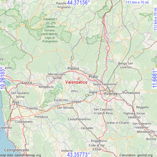
Valenzatico GPS coordinates[2]
43° 52' 0.48" North, 10° 57' 53.892" East
| Map corner | latitude | longitude |
|---|---|---|
| Upper-left | 44.37156°, | 10.26185° |
| Center: | 43.8668°, | 10.96497° |
| Lower-right: | 43.35773°, | 11.6681° |
| Map W x H: | 112.7×112.7 km | = 70×70mi |
| max Lat: | 47.04031° ⇑56.1% North |
| Valenzatico: | 43.8668° |
| min Lat: | ⇓43.9% South 35.50142° |
| min Long | Valenzatico | max Long |
| 6.69888° | 10.96497° | 18.48682° |
| W 42.2%⇐ | ⇒57.8% E |
Elevation
Elevation of Valenzatico is 41 m = 135 ft, and this is 265.7 m = 872 ft below average elevation for this country.
| Max E: |
2085 m = 6841 ft | 82.2% |
| Avg. | 306.7 m = 1006 ft | |
| Valenzatico | 41 m = 135 ft | |
Min E: |
-4 m = -13 ft | 17.8% |
See also: Italy elevation on elevation.city.
Geographical zone
Valenzatico is located in North temperate zone (between Tropic of Cancer and the Arctic Circle). Distance of this Northern Tropic circle is 2271.6 km =1411.5 mi to South.| Distance of | km | miles | from Valenzatico |
|---|---|---|---|
| North Pole | 5129.5 | 3187.3 | to North |
| Arctic Circle | 2523.6 | 1568.1 | to North |
| Tropic Cancer | 2271.6 | 1411.5 | to South |
| Equator | 4877.5 | 3030.7 | to South |


Nearby cities:
15 places around Valenzatico: (largest is in red/bold)
• Agliana
5.1 km =3.2 mi,  39°
39°
• Barba
2 km =1.2 mi,  26°
26°
• Cantagrillo-Casalguidi
4.1 km =2.5 mi,  273°
273°
• Carmignano
7.5 km =4.7 mi,  147°
147°
• Caserana
3.9 km =2.4 mi,  94°
94°
• Casini
3 km =1.9 mi,  108°
108°
• Catena
4.9 km =3 mi,  123°
123°
• Larciano
7.1 km =4.4 mi,  238°
238°
• Poggetto
7.3 km =4.5 mi,  126°
126°
• Quarrata
2.3 km =1.4 mi, 151°
• San Baronto
5 km =3.1 mi,  227°
227°
• Santonuovo
1.7 km =1.1 mi,  263°
263°
• Seano
6.1 km =3.8 mi, 131°
• Stazione
6.6 km =4.1 mi, 36°
• Vignole-Olmi
2 km =1.2 mi, 89°
Sources, notices
• [Note1] Compared only with cities in Italy existing in our database
• [Src1] Map data: © OpenStreetMap contributors (CC-BY-SA)
• [Src2] Other city data from geonames.org with taken over terms of usage.
• [Src3] Geographical zone / Annual Mean Temperature by Robert A. Rohde @ Wikipedia
