Cardano geodata
Cardano (Trentino-Alto Adige) is a seat of a third-order administrative division; located in Italy in Europe/Rome (GMT+2) time zone. With population of 442 people, there are 10122 cities with bigger population in this country. Compared to other cities in Italy, 98.3% of cities are located further ↓South; 52% of cities are located further →East and 60.5% of cities have lower elevation than Cardano. Note1
Administrative division(s):
- Level 1: Trentino-Alto Adige
- Level 2: Bolzano
- Level 3: Cornedo all'Isarco


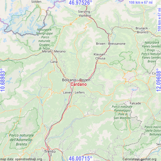
Cardano GPS coordinates[2]
46° 29' 36.096" North, 11° 23' 34.62" East
| Map corner | latitude | longitude |
|---|---|---|
| Upper-left | 46.97526°, | 10.68983° |
| Center: | 46.49336°, | 11.39295° |
| Lower-right: | 46.00715°, | 12.09608° |
| Map W x H: | 107.6×107.6 km | = 66.9×66.9mi |
| max Lat: | 47.04031° ⇑1.7% North |
| Cardano: | 46.49336° |
| min Lat: | ⇓98.3% South 35.50142° |
| min Long | Cardano | max Long |
| 6.69888° | 11.39295° | 18.48682° |
| W 48%⇐ | ⇒52% E |
Elevation
Elevation of Cardano is 303 m = 994 ft, and this is 3.7 m = 12 ft below average elevation for this country.
| Max E: |
2085 m = 6841 ft | 39.5% |
| Avg. | 306.7 m = 1006 ft | |
| Cardano | 303 m = 994 ft | |
Min E: |
-4 m = -13 ft | 60.5% |
See also: Italy elevation on elevation.city.
Geographical zone
Cardano is located in North temperate zone (between Tropic of Cancer and the Arctic Circle). Distance of this North polar circle is 2231.6 km =1386.7 mi to North.| Distance of | km | miles | from Cardano |
|---|---|---|---|
| North Pole | 4837.5 | 3005.9 | to North |
| Arctic Circle | 2231.6 | 1386.7 | to North |
| Tropic Cancer | 2563.7 | 1593 | to South |
| Equator | 5169.6 | 3212.2 | to South |


Nearby cities:
15 places around Cardano: (largest is in red/bold)
• Auna di Sotto
4.2 km =2.6 mi,  61°
61°
• Bolzano
4.1 km =2.5 mi,  265°
265°
• Collalbo
7.2 km =4.5 mi,  44°
44°
• Collepietra
4.8 km =3 mi,  100°
100°
• Cornaiano
9.2 km =5.7 mi,  248°
248°
• Cornedo All'Isarco
1.1 km =0.7 mi,  110°
110°
• Fiè Allo Sciliar
8.7 km =5.4 mi,  72°
72°
• Laives
8.5 km =5.3 mi,  209°
209°
• Nova Ponente
9.2 km =5.7 mi,  164°
164°
• Pineta
6.9 km =4.3 mi, 210°
• Renon - Ritten
7.3 km =4.5 mi, 42°
• San Genesio Atesino
6.7 km =4.2 mi,  313°
313°
• San Giacomo
6.1 km =3.8 mi,  227°
227°
• Settequerce
10 km =6.2 mi,  281°
281°
• Soprabolzano
4.1 km =2.5 mi,  12°
12°
Sources, notices
• [Note1] Compared only with cities in Italy existing in our database
• [Src1] Map data: © OpenStreetMap contributors (CC-BY-SA)
• [Src2] Other city data from geonames.org with taken over terms of usage.
• [Src3] Geographical zone / Annual Mean Temperature by Robert A. Rohde @ Wikipedia
