Calascio geodata
Calascio (Abruzzo) is a seat of a third-order administrative division; located in Italy in Europe/Rome (GMT+2) time zone. With population of 136 people, there are 11329 cities with bigger population in this country. Compared to other cities in Italy, 67.5% of cities are located further ↑North; 75.6% of cities are located further ←West and 98.7% of cities have lower elevation than Calascio. Note1


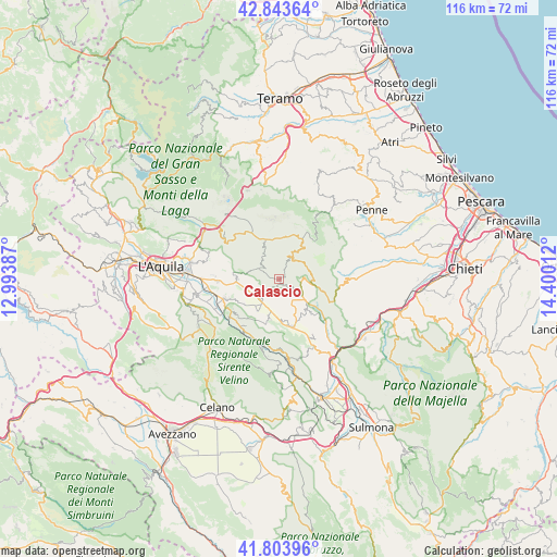
Calascio GPS coordinates[2]
42° 19' 33.42" North, 13° 41' 49.164" East
| Map corner | latitude | longitude |
|---|---|---|
| Upper-left | 42.84364°, | 12.99387° |
| Center: | 42.32595°, | 13.69699° |
| Lower-right: | 41.80396°, | 14.40012° |
| Map W x H: | 115.6×115.6 km | = 71.8×71.8mi |
| max Lat: | 47.04031° ⇑67.5% North |
| Calascio: | 42.32595° |
| min Lat: | ⇓32.5% South 35.50142° |
| min Long | Calascio | max Long |
| 6.69888° | 13.69699° | 18.48682° |
| W 75.6%⇐ | ⇒24.4% E |
Elevation
Elevation of Calascio is 1210 m = 3970 ft, and this is 903.3 m = 2964 ft above average elevation for this country.
| Max E: |
2085 m = 6841 ft | 1.3% |
| Calascio | 1210 m 3970 ft | |
| Avg. | 306.7 m = 1006 ft | |
Min E: |
-4 m = -13 ft | 98.7% |
See also: Italy elevation on elevation.city.
Geographical zone
Calascio is located in North temperate zone (between Tropic of Cancer and the Arctic Circle). Distance of this Northern Tropic circle is 2100.3 km =1305.1 mi to South.| Distance of | km | miles | from Calascio |
|---|---|---|---|
| North Pole | 5300.9 | 3293.8 | to North |
| Arctic Circle | 2695 | 1674.6 | to North |
| Tropic Cancer | 2100.3 | 1305.1 | to South |
| Equator | 4706.2 | 2924.3 | to South |


Nearby cities:
15 places around Calascio: (largest is in red/bold)
• Barisciano
8.8 km =5.5 mi,  269°
269°
• Capestrano
8.7 km =5.4 mi,  137°
137°
• Caporciano
8.6 km =5.3 mi,  192°
192°
• Carapelle Calvisio
3.1 km =1.9 mi,  196°
196°
• Castel del Monte
5 km =3.1 mi,  28°
28°
• Castelvecchio Calvisio
1.8 km =1.1 mi,  206°
206°
• Navelli
10.2 km =6.3 mi,  164°
164°
• Ofena
5.1 km =3.2 mi,  90°
90°
• Poggio Picenze
12.9 km =8 mi, 267°
• Prata d'Ansidonia
9 km =5.6 mi,  233°
233°
• San Demetrio Ne' Vestini
12.3 km =7.6 mi,  250°
250°
• San Pio delle Camere
5.7 km =3.5 mi,  216°
216°
• Santo Stefano di Sessanio
4.7 km =2.9 mi,  294°
294°
• Vallecupa
12.9 km =8 mi, 231°
• Villa Santa Lucia degli Abruzzi
6.7 km =4.2 mi,  83°
83°
Sources, notices
• [Note1] Compared only with cities in Italy existing in our database
• [Src1] Map data: © OpenStreetMap contributors (CC-BY-SA)
• [Src2] Other city data from geonames.org with taken over terms of usage.
• [Src3] Geographical zone / Annual Mean Temperature by Robert A. Rohde @ Wikipedia
