Canosa di Puglia geodata
Canosa di Puglia (Apulia) is a seat of a third-order administrative division; located in Italy in Europe/Rome (GMT+2) time zone. With population of 30,046 people, there are 274 cities with bigger population in this country. Compared to other cities in Italy, 76.8% of cities are located further ↑North; 93.2% of cities are located further ←West and 64.5% of cities have higher elevation than Canosa di Puglia. Note1
Administrative division(s):
- Level 1: Apulia
- Level 2: Provincia di Barletta - Andria - Trani
- Level 3: Canosa di Puglia


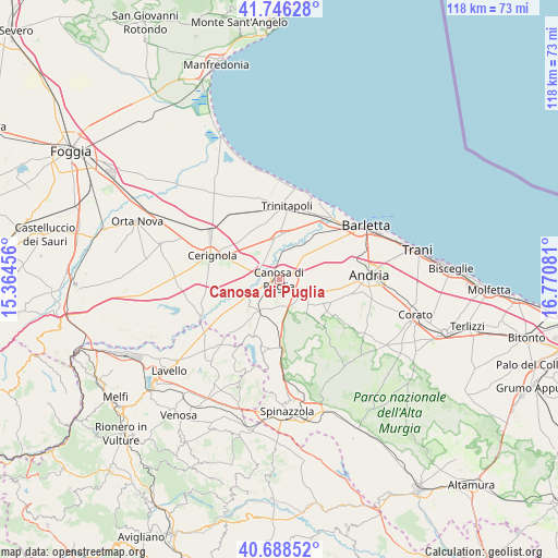
Canosa di Puglia GPS coordinates[2]
41° 13' 10.344" North, 16° 4' 3.648" East
| Map corner | latitude | longitude |
|---|---|---|
| Upper-left | 41.74628°, | 15.36456° |
| Center: | 41.21954°, | 16.06768° |
| Lower-right: | 40.68852°, | 16.77081° |
| Map W x H: | 117.6×117.6 km | = 73.1×73.1mi |
| max Lat: | 47.04031° ⇑76.8% North |
| Canosa di Puglia: | 41.21954° |
| min Lat: | ⇓23.2% South 35.50142° |
| min Long | Canosa di Pugli | max Long |
| 6.69888° | 16.06768° | 18.48682° |
| W 93.2%⇐ | ⇒6.8% E |
Elevation
Elevation of Canosa di Puglia is 131 m = 430 ft, and this is 175.7 m = 576 ft below average elevation for this country.
| Max E: |
2085 m = 6841 ft | 64.5% |
| Avg. | 306.7 m = 1006 ft | |
| Canosa di Puglia | 131 m = 430 ft | |
Min E: |
-4 m = -13 ft | 35.5% |
See also: Italy elevation on elevation.city.
Geographical zone
Canosa di Puglia is located in North temperate zone (between Tropic of Cancer and the Arctic Circle). Distance of this Northern Tropic circle is 1977.3 km =1228.6 mi to South.| Distance of | km | miles | from Canosa di Puglia |
|---|---|---|---|
| North Pole | 5423.9 | 3370.3 | to North |
| Arctic Circle | 2818 | 1751 | to North |
| Tropic Cancer | 1977.3 | 1228.6 | to South |
| Equator | 4583.2 | 2847.9 | to South |


Nearby cities:
15 places around Canosa di Puglia: (largest is in red/bold)
• Andria
19.3 km =12 mi,  86°
86°
• Barletta
20.8 km =12.9 mi,  59°
59°
• Capirro
29.9 km =18.6 mi,  82°
82°
• Cerignola
15.3 km =9.5 mi,  289°
289°
• Corato
29.7 km =18.5 mi,  104°
104°
• Margherita di Savoia
18.4 km =11.4 mi,  22°
22°
• Minervino Murge
15.2 km =9.4 mi,  176°
176°
• Montemilone
23 km =14.3 mi,  201°
201°
• San Ferdinando di Puglia
9.2 km =5.7 mi,  1°
1°
• Spinazzola
28.5 km =17.7 mi, 176°
• Stornara
26 km =16.2 mi, 286°
• Stornarella
28.5 km =17.7 mi,  278°
278°
• Trani
29.3 km =18.2 mi, 77°
• Trinitapoli
15.3 km =9.5 mi,  6°
6°
• Zapponeta
28 km =17.4 mi,  340°
340°
Sources, notices
• [Note1] Compared only with cities in Italy existing in our database
• [Src1] Map data: © OpenStreetMap contributors (CC-BY-SA)
• [Src2] Other city data from geonames.org with taken over terms of usage.
• [Src3] Geographical zone / Annual Mean Temperature by Robert A. Rohde @ Wikipedia
