Barletta geodata
Barletta (Apulia) is a seat of a second-order administrative division; located in Italy in Europe/Rome (GMT+2) time zone. With population of 93,279 people, there are 40 cities with bigger population in this country. Compared to other cities in Italy, 76% of cities are located further ↑North; 95% of cities are located further ←West and 89.6% of cities have higher elevation than Barletta. Note1
Administrative division(s):
- Level 1: Apulia
- Level 2: Provincia di Barletta - Andria - Trani
- Level 3: Barletta


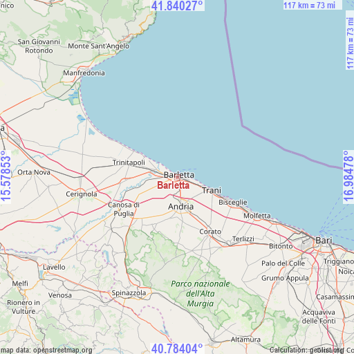
Barletta GPS coordinates[2]
41° 18' 51.444" North, 16° 16' 53.94" East
| Map corner | latitude | longitude |
|---|---|---|
| Upper-left | 41.84027°, | 15.57853° |
| Center: | 41.31429°, | 16.28165° |
| Lower-right: | 40.78404°, | 16.98478° |
| Map W x H: | 117.4×117.4 km | = 72.9×72.9mi |
| max Lat: | 47.04031° ⇑76% North |
| Barletta: | 41.31429° |
| min Lat: | ⇓24% South 35.50142° |
| min Long | Barletta | max Long |
| 6.69888° | 16.28165° | 18.48682° |
| W 95%⇐ | ⇒5% E |
Elevation
Elevation of Barletta is 19 m = 62 ft, and this is 287.7 m = 944 ft below average elevation for this country.
| Max E: |
2085 m = 6841 ft | 89.6% |
| Avg. | 306.7 m = 1006 ft | |
| Barletta | 19 m = 62 ft | |
Min E: |
-4 m = -13 ft | 10.4% |
See also: Barletta elevation on elevation.city.
Geographical zone
Barletta is located in North temperate zone (between Tropic of Cancer and the Arctic Circle). Distance of this Northern Tropic circle is 1987.8 km =1235.2 mi to South.| Distance of | km | miles | from Barletta |
|---|---|---|---|
| North Pole | 5413.3 | 3363.7 | to North |
| Arctic Circle | 2807.5 | 1744.5 | to North |
| Tropic Cancer | 1987.8 | 1235.2 | to South |
| Equator | 4593.7 | 2854.4 | to South |


Nearby cities:
15 places around Barletta: (largest is in red/bold)
• Andria
9.3 km =5.8 mi,  171°
171°
• Bisceglie
20 km =12.4 mi,  113°
113°
• Canosa di Puglia
20.8 km =12.9 mi,  239°
239°
• Capirro
13.5 km =8.4 mi,  119°
119°
• Cerignola
32.7 km =20.3 mi,  260°
260°
• Corato
21.1 km =13.1 mi,  149°
149°
• Margherita di Savoia
12.5 km =7.8 mi,  300°
300°
• Minervino Murge
30.9 km =19.2 mi,  213°
213°
• Molfetta
29.4 km =18.3 mi, 115°
• Ruvo di Puglia
27.7 km =17.2 mi,  142°
142°
• San Ferdinando di Puglia
17.7 km =11 mi,  265°
265°
• Terlizzi
30.2 km =18.8 mi,  133°
133°
• Trani
11.5 km =7.1 mi, 110°
• Trinitapoli
16.7 km =10.4 mi,  286°
286°
• Zapponeta
31.5 km =19.6 mi, 300°
Sources, notices
• [Note1] Compared only with cities in Italy existing in our database
• [Src1] Map data: © OpenStreetMap contributors (CC-BY-SA)
• [Src2] Other city data from geonames.org with taken over terms of usage.
• [Src3] Geographical zone / Annual Mean Temperature by Robert A. Rohde @ Wikipedia
