Stornara geodata
Stornara (Apulia) is a seat of a third-order administrative division; located in Italy in Europe/Rome (GMT+2) time zone. With population of 5,144 people, there are 1902 cities with bigger population in this country. Compared to other cities in Italy, 76.2% of cities are located further ↑North; 91.6% of cities are located further ←West and 68.1% of cities have higher elevation than Stornara. Note1


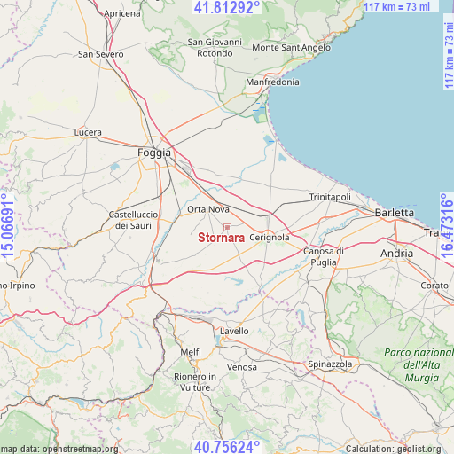
Stornara GPS coordinates[2]
41° 17' 12.192" North, 15° 46' 12.108" East
| Map corner | latitude | longitude |
|---|---|---|
| Upper-left | 41.81292°, | 15.06691° |
| Center: | 41.28672°, | 15.77003° |
| Lower-right: | 40.75624°, | 16.47316° |
| Map W x H: | 117.5×117.5 km | = 73×73mi |
| max Lat: | 47.04031° ⇑76.2% North |
| Stornara: | 41.28672° |
| min Lat: | ⇓23.8% South 35.50142° |
| min Long | Stornara | max Long |
| 6.69888° | 15.77003° | 18.48682° |
| W 91.6%⇐ | ⇒8.4% E |
Elevation
Elevation of Stornara is 108 m = 354 ft, and this is 198.7 m = 652 ft below average elevation for this country.
| Max E: |
2085 m = 6841 ft | 68.1% |
| Avg. | 306.7 m = 1006 ft | |
| Stornara | 108 m = 354 ft | |
Min E: |
-4 m = -13 ft | 31.9% |
See also: Italy elevation on elevation.city.
Geographical zone
Stornara is located in North temperate zone (between Tropic of Cancer and the Arctic Circle). Distance of this Northern Tropic circle is 1984.7 km =1233.2 mi to South.| Distance of | km | miles | from Stornara |
|---|---|---|---|
| North Pole | 5416.4 | 3365.6 | to North |
| Arctic Circle | 2810.5 | 1746.4 | to North |
| Tropic Cancer | 1984.7 | 1233.2 | to South |
| Equator | 4590.7 | 2852.5 | to South |


Nearby cities:
15 places around Stornara: (largest is in red/bold)
• Ascoli Satriano
19.4 km =12.1 mi,  241°
241°
• Candela
27.1 km =16.8 mi,  231°
231°
• Canosa di Puglia
26 km =16.2 mi,  106°
106°
• Carapelle
10.7 km =6.6 mi,  323°
323°
• Castelluccio dei Sauri
24.7 km =15.3 mi,  274°
274°
• Cerignola
10.8 km =6.7 mi,  102°
102°
• Foggia
26.4 km =16.4 mi, 316°
• Lavello
26.6 km =16.5 mi,  176°
176°
• Ordona
12.2 km =7.6 mi,  284°
284°
• Orta Nova
6.9 km =4.3 mi,  312°
312°
• Pantano
24.5 km =15.2 mi, 312°
• San Ferdinando di Puglia
25.2 km =15.7 mi,  85°
85°
• Stornarella
4.8 km =3 mi,  224°
224°
• Trinitapoli
27.8 km =17.3 mi,  73°
73°
• Zapponeta
24.5 km =15.2 mi,  39°
39°
Sources, notices
• [Note1] Compared only with cities in Italy existing in our database
• [Src1] Map data: © OpenStreetMap contributors (CC-BY-SA)
• [Src2] Other city data from geonames.org with taken over terms of usage.
• [Src3] Geographical zone / Annual Mean Temperature by Robert A. Rohde @ Wikipedia
