Borgagne geodata
Borgagne (Apulia) is a populated place; located in Italy in Europe/Rome (GMT+2) time zone. With population of 2,073 people, there are 4030 cities with bigger population in this country. Compared to other cities in Italy, 86.2% of cities are located further ↑North; 99.9% of cities are located further ←West and 86.1% of cities have higher elevation than Borgagne. Note1


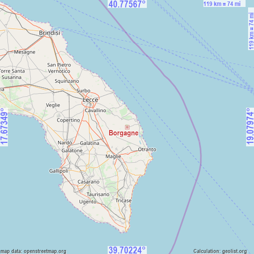
Borgagne GPS coordinates[2]
40° 14' 27.888" North, 18° 22' 35.796" East
| Map corner | latitude | longitude |
|---|---|---|
| Upper-left | 40.77567°, | 17.67349° |
| Center: | 40.24108°, | 18.37661° |
| Lower-right: | 39.70224°, | 19.07974° |
| Map W x H: | 119.4×119.4 km | = 74.2×74.2mi |
| max Lat: | 47.04031° ⇑86.2% North |
| Borgagne: | 40.24108° |
| min Lat: | ⇓13.8% South 35.50142° |
| min Long | Borgagne | max Long |
| 6.69888° | 18.37661° | 18.48682° |
| W 99.9%⇐ | ⇒0.099999999999994% E |
Elevation
Elevation of Borgagne is 28 m = 92 ft, and this is 278.7 m = 914 ft below average elevation for this country.
| Max E: |
2085 m = 6841 ft | 86.1% |
| Avg. | 306.7 m = 1006 ft | |
| Borgagne | 28 m = 92 ft | |
Min E: |
-4 m = -13 ft | 13.9% |
See also: Italy elevation on elevation.city.
Geographical zone
Borgagne is located in North temperate zone (between Tropic of Cancer and the Arctic Circle). Distance of this Northern Tropic circle is 1868.5 km =1161 mi to South.| Distance of | km | miles | from Borgagne |
|---|---|---|---|
| North Pole | 5532.7 | 3437.9 | to North |
| Arctic Circle | 2926.8 | 1818.6 | to North |
| Tropic Cancer | 1868.5 | 1161 | to South |
| Equator | 4474.4 | 2780.3 | to South |


Nearby cities:
15 places around Borgagne: (largest is in red/bold)
• Acquarica
8.9 km =5.5 mi,  324°
324°
• Bagnolo del Salento
10.4 km =6.5 mi,  191°
191°
• Calimera
8.3 km =5.2 mi,  276°
276°
• Cannole
8.4 km =5.2 mi, 186°
• Caprarica di Lecce
11.4 km =7.1 mi, 280°
• Carpignano Salentino
6 km =3.7 mi,  212°
212°
• Castri di Lecce
10.3 km =6.4 mi,  290°
290°
• Castrignano De' Greci
10.1 km =6.3 mi,  222°
222°
• Cursi
11.5 km =7.1 mi, 206°
• Martano
7.7 km =4.8 mi,  235°
235°
• Martignano
10.2 km =6.3 mi,  268°
268°
• Melendugno
4.8 km =3 mi, 316°
• Pisignano
11.4 km =7.1 mi,  308°
308°
• Serrano
6.7 km =4.2 mi,  198°
198°
• Vernole
8.3 km =5.2 mi, 309°
Sources, notices
• [Note1] Compared only with cities in Italy existing in our database
• [Src1] Map data: © OpenStreetMap contributors (CC-BY-SA)
• [Src2] Other city data from geonames.org with taken over terms of usage.
• [Src3] Geographical zone / Annual Mean Temperature by Robert A. Rohde @ Wikipedia
