Candiolo geodata
Candiolo (Piedmont) is a seat of a third-order administrative division; located in Italy in Europe/Rome (GMT+2) time zone. With population of 5,452 people, there are 1798 cities with bigger population in this country. Compared to other cities in Italy, 59% of cities are located further ↓South; 97.1% of cities are located further →East and 50.9% of cities have lower elevation than Candiolo. Note1


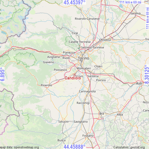
Candiolo GPS coordinates[2]
44° 57' 30.888" North, 7° 35' 53.232" East
| Map corner | latitude | longitude |
|---|---|---|
| Upper-left | 45.45397°, | 6.895° |
| Center: | 44.95858°, | 7.59812° |
| Lower-right: | 44.45888°, | 8.30125° |
| Map W x H: | 110.6×110.6 km | = 68.7×68.7mi |
| max Lat: | 47.04031° ⇑41% North |
| Candiolo: | 44.95858° |
| min Lat: | ⇓59% South 35.50142° |
| min Long | Candiolo | max Long |
| 6.69888° | 7.59812° | 18.48682° |
| W 2.9%⇐ | ⇒97.1% E |
Elevation
Elevation of Candiolo is 240 m = 787 ft, and this is 66.7 m = 219 ft below average elevation for this country.
| Max E: |
2085 m = 6841 ft | 49.1% |
| Avg. | 306.7 m = 1006 ft | |
| Candiolo | 240 m = 787 ft | |
Min E: |
-4 m = -13 ft | 50.9% |
See also: Italy elevation on elevation.city.
Geographical zone
Candiolo is located in North temperate zone (between Tropic of Cancer and the Arctic Circle). Distance of this Northern Tropic circle is 2393 km =1486.9 mi to South.| Distance of | km | miles | from Candiolo |
|---|---|---|---|
| North Pole | 5008.1 | 3111.9 | to North |
| Arctic Circle | 2402.2 | 1492.7 | to North |
| Tropic Cancer | 2393 | 1486.9 | to South |
| Equator | 4998.9 | 3106.2 | to South |


Nearby cities:
15 places around Candiolo: (largest is in red/bold)
• Beinasco
7.4 km =4.6 mi,  352°
352°
• Borgo Melano
6.6 km =4.1 mi, 345°
• Castagnole Piemonte
7.2 km =4.5 mi,  200°
200°
• Fornaci
7.7 km =4.8 mi,  0°
0°
• Garino
2.2 km =1.4 mi,  42°
42°
• Gerbole-Zucche
7.1 km =4.4 mi,  295°
295°
• La Loggia
5.6 km =3.5 mi,  94°
94°
• Nichelino
6.3 km =3.9 mi, 42°
• None
5.2 km =3.2 mi,  241°
241°
• Orbassano
7 km =4.3 mi,  317°
317°
• Pasta
6.9 km =4.3 mi,  328°
328°
• Piobesi Torinese
3 km =1.9 mi,  161°
161°
• Tagliaferro
5.7 km =3.5 mi,  66°
66°
• Vinovo
3 km =1.9 mi,  115°
115°
• Volvera
6.8 km =4.2 mi,  266°
266°
Sources, notices
• [Note1] Compared only with cities in Italy existing in our database
• [Src1] Map data: © OpenStreetMap contributors (CC-BY-SA)
• [Src2] Other city data from geonames.org with taken over terms of usage.
• [Src3] Geographical zone / Annual Mean Temperature by Robert A. Rohde @ Wikipedia
