Canal San Bovo geodata
Canal San Bovo (Trentino-Alto Adige) is a seat of a third-order administrative division; located in Italy in Europe/Rome (GMT+2) time zone. With population of 409 people, there are 10241 cities with bigger population in this country. Compared to other cities in Italy, 95.2% of cities are located further ↓South; 52.3% of cities are located further ←West and 90.6% of cities have lower elevation than Canal San Bovo. Note1
Administrative division(s):
- Level 1: Trentino-Alto Adige
- Level 2: Provincia autonoma di Trento
- Level 3: Canal San Bovo


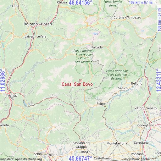
Canal San Bovo GPS coordinates[2]
46° 9' 24.012" North, 11° 43' 47.928" East
| Map corner | latitude | longitude |
|---|---|---|
| Upper-left | 46.64156°, | 11.02686° |
| Center: | 46.15667°, | 11.72998° |
| Lower-right: | 45.66747°, | 12.43311° |
| Map W x H: | 108.3×108.3 km | = 67.3×67.3mi |
| max Lat: | 47.04031° ⇑4.8% North |
| Canal San Bovo: | 46.15667° |
| min Lat: | ⇓95.2% South 35.50142° |
| min Long | Canal San Bovo | max Long |
| 6.69888° | 11.72998° | 18.48682° |
| W 52.3%⇐ | ⇒47.7% E |
Elevation
Elevation of Canal San Bovo is 734 m = 2408 ft, and this is 427.3 m = 1402 ft above average elevation for this country.
| Max E: |
2085 m = 6841 ft | 9.4% |
| Canal San Bovo | 734 m 2408 ft | |
| Avg. | 306.7 m = 1006 ft | |
Min E: |
-4 m = -13 ft | 90.6% |
See also: Italy elevation on elevation.city.
Geographical zone
Canal San Bovo is located in North temperate zone (between Tropic of Cancer and the Arctic Circle). Distance of this North polar circle is 2269 km =1409.9 mi to North.| Distance of | km | miles | from Canal San Bovo |
|---|---|---|---|
| North Pole | 4874.9 | 3029.1 | to North |
| Arctic Circle | 2269 | 1409.9 | to North |
| Tropic Cancer | 2526.2 | 1569.7 | to South |
| Equator | 5132.1 | 3188.9 | to South |


Nearby cities:
15 places around Canal San Bovo: (largest is in red/bold)
• Bieno
15.8 km =9.8 mi,  238°
238°
• Castello Tesino
12.8 km =8 mi,  215°
215°
• Cinte Tesino
14.2 km =8.8 mi, 218°
• Fiera di Primiero
7.9 km =4.9 mi,  74°
74°
• Fonzaso
16.5 km =10.3 mi,  161°
161°
• Imer
4.6 km =2.9 mi,  100°
100°
• Lamon
12.3 km =7.6 mi,  172°
172°
• Mezzano
6.1 km =3.8 mi,  92°
92°
• Pieve Tesino
13.4 km =8.3 mi, 222°
• Sagron Mis
17 km =10.6 mi,  75°
75°
• Servo
11.8 km =7.3 mi, 158°
• Siror
8.5 km =5.3 mi, 66°
• Sovramonte
11.7 km =7.3 mi, 158°
• Tonadico
8.9 km =5.5 mi, 72°
• Transacqua
8.1 km =5 mi, 76°
Sources, notices
• [Note1] Compared only with cities in Italy existing in our database
• [Src1] Map data: © OpenStreetMap contributors (CC-BY-SA)
• [Src2] Other city data from geonames.org with taken over terms of usage.
• [Src3] Geographical zone / Annual Mean Temperature by Robert A. Rohde @ Wikipedia
