Fonzaso geodata
Fonzaso (Veneto) is a seat of a third-order administrative division; located in Italy in Europe/Rome (GMT+2) time zone. With population of 1,947 people, there are 4253 cities with bigger population in this country. Compared to other cities in Italy, 92.3% of cities are located further ↓South; 53.1% of cities are located further ←West and 62.8% of cities have lower elevation than Fonzaso. Note1


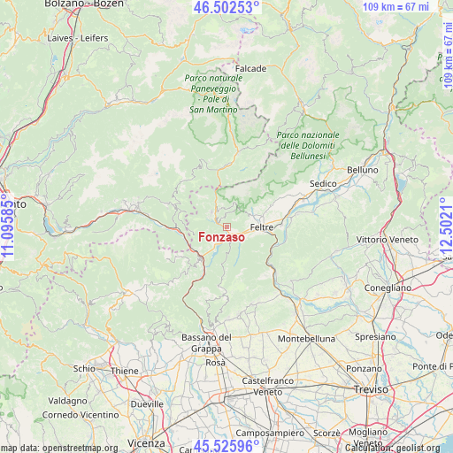
Fonzaso GPS coordinates[2]
46° 0' 59.04" North, 11° 47' 56.292" East
| Map corner | latitude | longitude |
|---|---|---|
| Upper-left | 46.50253°, | 11.09585° |
| Center: | 46.0164°, | 11.79897° |
| Lower-right: | 45.52596°, | 12.5021° |
| Map W x H: | 108.6×108.6 km | = 67.5×67.5mi |
| max Lat: | 47.04031° ⇑7.7% North |
| Fonzaso: | 46.0164° |
| min Lat: | ⇓92.3% South 35.50142° |
| min Long | Fonzaso | max Long |
| 6.69888° | 11.79897° | 18.48682° |
| W 53.1%⇐ | ⇒46.9% E |
Elevation
Elevation of Fonzaso is 322 m = 1056 ft, and this is 15.3 m = 50 ft above average elevation for this country.
| Max E: |
2085 m = 6841 ft | 37.2% |
| Fonzaso | 322 m 1056 ft | |
| Avg. | 306.7 m = 1006 ft | |
Min E: |
-4 m = -13 ft | 62.8% |
See also: Italy elevation on elevation.city.
Geographical zone
Fonzaso is located in North temperate zone (between Tropic of Cancer and the Arctic Circle). Distance of this North polar circle is 2284.6 km =1419.6 mi to North.| Distance of | km | miles | from Fonzaso |
|---|---|---|---|
| North Pole | 4890.5 | 3038.8 | to North |
| Arctic Circle | 2284.6 | 1419.6 | to North |
| Tropic Cancer | 2510.6 | 1560 | to South |
| Equator | 5116.5 | 3179.2 | to South |


Nearby cities:
15 places around Fonzaso: (largest is in red/bold)
• Anzù
10.4 km =6.5 mi,  94°
94°
• Arsiè
5 km =3.1 mi,  219°
219°
• Arten
2.5 km =1.6 mi,  112°
112°
• Cismon del Grappa
12 km =7.5 mi,  207°
207°
• Enego
11 km =6.8 mi, 220°
• Facen-Travagola
5.1 km =3.2 mi,  73°
73°
• Feltre
7.8 km =4.8 mi, 86°
• Foen
9 km =5.6 mi, 72°
• Lamon
5.1 km =3.2 mi,  312°
312°
• Pedavena
7 km =4.3 mi, 68°
• Seren del Grappa
5 km =3.1 mi,  117°
117°
• Servo
4.8 km =3 mi,  348°
348°
• Sovramonte
4.8 km =3 mi, 348°
• Tezze
10.4 km =6.5 mi,  254°
254°
• Villabruna-Umin
10.9 km =6.8 mi, 65°
Sources, notices
• [Note1] Compared only with cities in Italy existing in our database
• [Src1] Map data: © OpenStreetMap contributors (CC-BY-SA)
• [Src2] Other city data from geonames.org with taken over terms of usage.
• [Src3] Geographical zone / Annual Mean Temperature by Robert A. Rohde @ Wikipedia
