Canale geodata
Canale (Piedmont) is a seat of a third-order administrative division; located in Italy in Europe/Rome (GMT+2) time zone. With population of 4,426 people, there are 2177 cities with bigger population in this country. Compared to other cities in Italy, 56.1% of cities are located further ↓South; 93.7% of cities are located further →East and 56.5% of cities have higher elevation than Canale. Note1


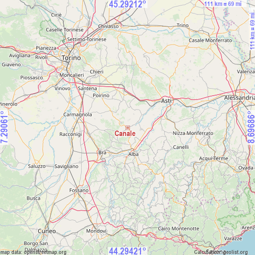
Canale GPS coordinates[2]
44° 47' 43.152" North, 7° 59' 37.428" East
| Map corner | latitude | longitude |
|---|---|---|
| Upper-left | 45.29212°, | 7.29061° |
| Center: | 44.79532°, | 7.99373° |
| Lower-right: | 44.29421°, | 8.69686° |
| Map W x H: | 111×111 km | = 69×69mi |
| max Lat: | 47.04031° ⇑43.9% North |
| Canale: | 44.79532° |
| min Lat: | ⇓56.1% South 35.50142° |
| min Long | Canale | max Long |
| 6.69888° | 7.99373° | 18.48682° |
| W 6.3%⇐ | ⇒93.7% E |
Elevation
Elevation of Canale is 191 m = 627 ft, and this is 115.7 m = 380 ft below average elevation for this country.
| Max E: |
2085 m = 6841 ft | 56.5% |
| Avg. | 306.7 m = 1006 ft | |
| Canale | 191 m = 627 ft | |
Min E: |
-4 m = -13 ft | 43.5% |
See also: Italy elevation on elevation.city.
Geographical zone
Canale is located in North temperate zone (between Tropic of Cancer and the Arctic Circle). Distance of this Northern Tropic circle is 2374.9 km =1475.7 mi to South.| Distance of | km | miles | from Canale |
|---|---|---|---|
| North Pole | 5026.3 | 3123.2 | to North |
| Arctic Circle | 2420.4 | 1504 | to North |
| Tropic Cancer | 2374.9 | 1475.7 | to South |
| Equator | 4980.8 | 3094.9 | to South |


Nearby cities:
15 places around Canale: (largest is in red/bold)
• Castagnito
5.4 km =3.4 mi,  146°
146°
• Castellinaldo
3.6 km =2.2 mi,  128°
128°
• Cisterna d'Asti
3.4 km =2.1 mi,  9°
9°
• Corneliano d'Alba
7.2 km =4.5 mi,  203°
203°
• Guarene
7 km =4.3 mi, 151°
• Magliano Alfieri
6.7 km =4.2 mi,  115°
115°
• Montaldo Roero
6.2 km =3.9 mi,  241°
241°
• Monteu Roero
5 km =3.1 mi,  250°
250°
• Montà
3.8 km =2.4 mi,  305°
305°
• Piobesi d'Alba
6.9 km =4.3 mi,  189°
189°
• Priocca
5.7 km =3.5 mi,  100°
100°
• San Damiano d'Asti
6.9 km =4.3 mi,  52°
52°
• San Giuseppe
6.7 km =4.2 mi,  136°
136°
• Santo Stefano Roero
4.2 km =2.6 mi,  259°
259°
• Vezza d'Alba
3.8 km =2.4 mi,  162°
162°
Sources, notices
• [Note1] Compared only with cities in Italy existing in our database
• [Src1] Map data: © OpenStreetMap contributors (CC-BY-SA)
• [Src2] Other city data from geonames.org with taken over terms of usage.
• [Src3] Geographical zone / Annual Mean Temperature by Robert A. Rohde @ Wikipedia
