Priocca geodata
Priocca (Piedmont) is a seat of a third-order administrative division; located in Italy in Europe/Rome (GMT+2) time zone. With population of 1,668 people, there are 4740 cities with bigger population in this country. Compared to other cities in Italy, 55.9% of cities are located further ↓South; 92.8% of cities are located further →East and 53.2% of cities have higher elevation than Priocca. Note1


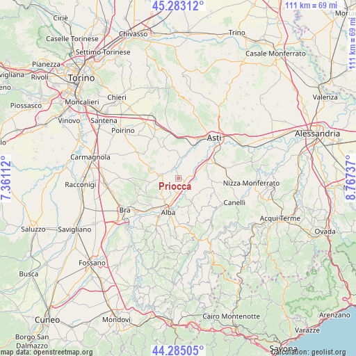
Priocca GPS coordinates[2]
44° 47' 10.464" North, 8° 3' 51.264" East
| Map corner | latitude | longitude |
|---|---|---|
| Upper-left | 45.28312°, | 7.36112° |
| Center: | 44.78624°, | 8.06424° |
| Lower-right: | 44.28505°, | 8.76737° |
| Map W x H: | 111×111 km | = 69×69mi |
| max Lat: | 47.04031° ⇑44.1% North |
| Priocca: | 44.78624° |
| min Lat: | ⇓55.9% South 35.50142° |
| min Long | Priocca | max Long |
| 6.69888° | 8.06424° | 18.48682° |
| W 7.2%⇐ | ⇒92.8% E |
Elevation
Elevation of Priocca is 215 m = 705 ft, and this is 91.7 m = 301 ft below average elevation for this country.
| Max E: |
2085 m = 6841 ft | 53.2% |
| Avg. | 306.7 m = 1006 ft | |
| Priocca | 215 m = 705 ft | |
Min E: |
-4 m = -13 ft | 46.8% |
See also: Italy elevation on elevation.city.
Geographical zone
Priocca is located in North temperate zone (between Tropic of Cancer and the Arctic Circle). Distance of this Northern Tropic circle is 2373.8 km =1475 mi to South.| Distance of | km | miles | from Priocca |
|---|---|---|---|
| North Pole | 5027.3 | 3123.8 | to North |
| Arctic Circle | 2421.4 | 1504.6 | to North |
| Tropic Cancer | 2373.8 | 1475 | to South |
| Equator | 4979.8 | 3094.3 | to South |


Nearby cities:
15 places around Priocca: (largest is in red/bold)
• Baraccone
4.4 km =2.7 mi,  181°
181°
• Canale
5.7 km =3.5 mi,  280°
280°
• Canove
2.4 km =1.5 mi,  114°
114°
• Castagnito
4.3 km =2.7 mi,  216°
216°
• Castellinaldo
3 km =1.9 mi,  245°
245°
• Cisterna d'Asti
6.6 km =4.1 mi,  310°
310°
• Govone
3.1 km =1.9 mi,  49°
49°
• Guarene
5.6 km =3.5 mi,  204°
204°
• Magliano Alfieri
1.9 km =1.2 mi,  166°
166°
• San Damiano d'Asti
5.2 km =3.2 mi,  359°
359°
• San Giuseppe
4 km =2.5 mi,  193°
193°
• San Martino Alfieri
5 km =3.1 mi, 45°
• Sant'Antonio
3.1 km =1.9 mi, 171°
• Vaccheria
6.8 km =4.2 mi, 194°
• Vezza d'Alba
5.2 km =3.2 mi,  239°
239°
Sources, notices
• [Note1] Compared only with cities in Italy existing in our database
• [Src1] Map data: © OpenStreetMap contributors (CC-BY-SA)
• [Src2] Other city data from geonames.org with taken over terms of usage.
• [Src3] Geographical zone / Annual Mean Temperature by Robert A. Rohde @ Wikipedia
