Castagnito geodata
Castagnito (Piedmont) is a seat of a third-order administrative division; located in Italy in Europe/Rome (GMT+2) time zone. With population of 530 people, there are 9642 cities with bigger population in this country. Compared to other cities in Italy, 55.4% of cities are located further ↓South; 93.2% of cities are located further →East and 63.4% of cities have lower elevation than Castagnito. Note1


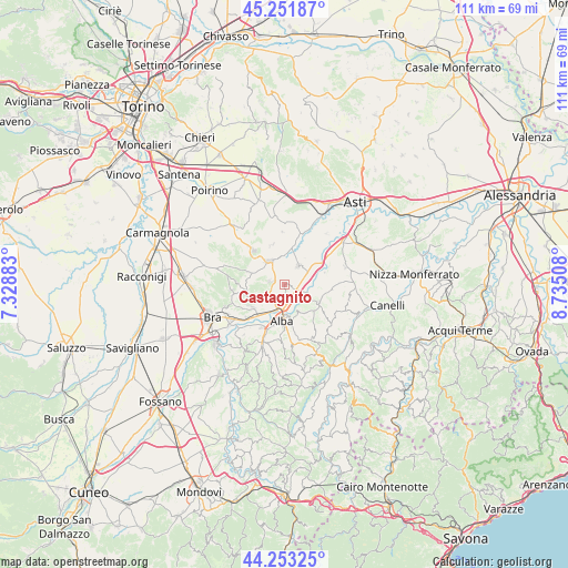
Castagnito GPS coordinates[2]
44° 45' 16.992" North, 8° 1' 55.02" East
| Map corner | latitude | longitude |
|---|---|---|
| Upper-left | 45.25187°, | 7.32883° |
| Center: | 44.75472°, | 8.03195° |
| Lower-right: | 44.25325°, | 8.73508° |
| Map W x H: | 111×111 km | = 69×69mi |
| max Lat: | 47.04031° ⇑44.6% North |
| Castagnito: | 44.75472° |
| min Lat: | ⇓55.4% South 35.50142° |
| min Long | Castagnito | max Long |
| 6.69888° | 8.03195° | 18.48682° |
| W 6.8%⇐ | ⇒93.2% E |
Elevation
Elevation of Castagnito is 328 m = 1076 ft, and this is 21.3 m = 70 ft above average elevation for this country.
| Max E: |
2085 m = 6841 ft | 36.6% |
| Castagnito | 328 m 1076 ft | |
| Avg. | 306.7 m = 1006 ft | |
Min E: |
-4 m = -13 ft | 63.4% |
See also: Italy elevation on elevation.city.
Geographical zone
Castagnito is located in North temperate zone (between Tropic of Cancer and the Arctic Circle). Distance of this Northern Tropic circle is 2370.3 km =1472.8 mi to South.| Distance of | km | miles | from Castagnito |
|---|---|---|---|
| North Pole | 5030.8 | 3126 | to North |
| Arctic Circle | 2424.9 | 1506.8 | to North |
| Tropic Cancer | 2370.3 | 1472.8 | to South |
| Equator | 4976.3 | 3092.1 | to South |


Nearby cities:
15 places around Castagnito: (largest is in red/bold)
• Baraccone
2.6 km =1.6 mi,  111°
111°
• Barbaresco
5.3 km =3.3 mi,  131°
131°
• Canale
5.4 km =3.4 mi,  326°
326°
• Canove
5.4 km =3.4 mi,  62°
62°
• Castellinaldo
2.2 km =1.4 mi,  355°
355°
• Castelrotto
3.4 km =2.1 mi,  209°
209°
• Guarene
1.7 km =1.1 mi,  171°
171°
• Magliano Alfieri
3.4 km =2.1 mi, 61°
• Mussotto
4.1 km =2.5 mi,  177°
177°
• Piobesi d'Alba
4.7 km =2.9 mi,  241°
241°
• Priocca
4.3 km =2.7 mi,  36°
36°
• San Giuseppe
1.7 km =1.1 mi,  102°
102°
• Sant'Antonio
3 km =1.9 mi,  81°
81°
• Vaccheria
3.2 km =2 mi,  164°
164°
• Vezza d'Alba
2.1 km =1.3 mi,  295°
295°
Sources, notices
• [Note1] Compared only with cities in Italy existing in our database
• [Src1] Map data: © OpenStreetMap contributors (CC-BY-SA)
• [Src2] Other city data from geonames.org with taken over terms of usage.
• [Src3] Geographical zone / Annual Mean Temperature by Robert A. Rohde @ Wikipedia
