Ripabottoni geodata
Ripabottoni (Molise) is a seat of a third-order administrative division; located in Italy in Europe/Rome (GMT+2) time zone. With population of 427 people, there are 10176 cities with bigger population in this country. Compared to other cities in Italy, 73% of cities are located further ↑North; 85.6% of cities are located further ←West and 85.7% of cities have lower elevation than Ripabottoni. Note1


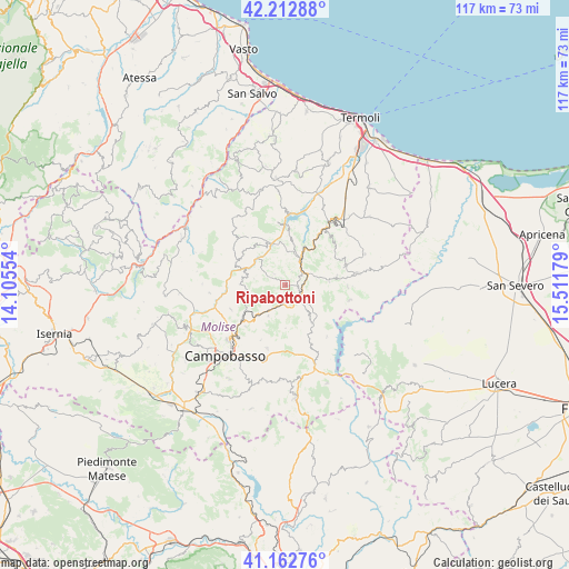
Ripabottoni GPS coordinates[2]
41° 41' 23.856" North, 14° 48' 31.176" East
| Map corner | latitude | longitude |
|---|---|---|
| Upper-left | 42.21288°, | 14.10554° |
| Center: | 41.68996°, | 14.80866° |
| Lower-right: | 41.16276°, | 15.51179° |
| Map W x H: | 116.8×116.8 km | = 72.6×72.6mi |
| max Lat: | 47.04031° ⇑73% North |
| Ripabottoni: | 41.68996° |
| min Lat: | ⇓27% South 35.50142° |
| min Long | Ripabottoni | max Long |
| 6.69888° | 14.80866° | 18.48682° |
| W 85.6%⇐ | ⇒14.4% E |
Elevation
Elevation of Ripabottoni is 626 m = 2054 ft, and this is 319.3 m = 1048 ft above average elevation for this country.
| Max E: |
2085 m = 6841 ft | 14.3% |
| Ripabottoni | 626 m 2054 ft | |
| Avg. | 306.7 m = 1006 ft | |
Min E: |
-4 m = -13 ft | 85.7% |
See also: Italy elevation on elevation.city.
Geographical zone
Ripabottoni is located in North temperate zone (between Tropic of Cancer and the Arctic Circle). Distance of this Northern Tropic circle is 2029.6 km =1261.1 mi to South.| Distance of | km | miles | from Ripabottoni |
|---|---|---|---|
| North Pole | 5371.6 | 3337.8 | to North |
| Arctic Circle | 2765.7 | 1718.5 | to North |
| Tropic Cancer | 2029.6 | 1261.1 | to South |
| Equator | 4635.5 | 2880.4 | to South |


Nearby cities:
15 places around Ripabottoni: (largest is in red/bold)
• Bonefro
10.6 km =6.6 mi,  80°
80°
• Campolieto
7.2 km =4.5 mi,  208°
208°
• Casacalenda
6.3 km =3.9 mi,  30°
30°
• Castelbottaccio
11 km =6.8 mi,  309°
309°
• Castellino del Biferno
6.5 km =4 mi,  281°
281°
• Lucito
11.1 km =6.9 mi,  294°
294°
• Lupara
10.1 km =6.3 mi,  322°
322°
• Matrice
11.4 km =7.1 mi,  226°
226°
• Monacilioni
8.8 km =5.5 mi,  179°
179°
• Montagano
12.2 km =7.6 mi,  246°
246°
• Morrone del Sannio
3.3 km =2.1 mi, 315°
• Petrella Tifernina
9.2 km =5.7 mi,  270°
270°
• Provvidenti
3.3 km =2.1 mi,  21°
21°
• San Giovanni in Galdo
12 km =7.5 mi,  203°
203°
• Sant'Elia a Pianisi
9.5 km =5.9 mi,  144°
144°
Sources, notices
• [Note1] Compared only with cities in Italy existing in our database
• [Src1] Map data: © OpenStreetMap contributors (CC-BY-SA)
• [Src2] Other city data from geonames.org with taken over terms of usage.
• [Src3] Geographical zone / Annual Mean Temperature by Robert A. Rohde @ Wikipedia
