Calci geodata
Calci (Tuscany) is a seat of a third-order administrative division; located in Italy in Europe/Rome (GMT+2) time zone. With population of 4,529 people, there are 2135 cities with bigger population in this country. Compared to other cities in Italy, 57.8% of cities are located further ↑North; 62.6% of cities are located further →East and 80.5% of cities have higher elevation than Calci. Note1


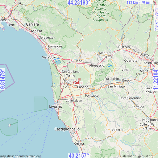
Calci GPS coordinates[2]
43° 43' 33.492" North, 10° 31' 4.476" East
| Map corner | latitude | longitude |
|---|---|---|
| Upper-left | 44.23193°, | 9.81479° |
| Center: | 43.72597°, | 10.51791° |
| Lower-right: | 43.2157°, | 11.22104° |
| Map W x H: | 113×113 km | = 70.2×70.2mi |
| max Lat: | 47.04031° ⇑57.8% North |
| Calci: | 43.72597° |
| min Lat: | ⇓42.2% South 35.50142° |
| min Long | Calci | max Long |
| 6.69888° | 10.51791° | 18.48682° |
| W 37.4%⇐ | ⇒62.6% E |
Elevation
Elevation of Calci is 47 m = 154 ft, and this is 259.7 m = 852 ft below average elevation for this country.
| Max E: |
2085 m = 6841 ft | 80.5% |
| Avg. | 306.7 m = 1006 ft | |
| Calci | 47 m = 154 ft | |
Min E: |
-4 m = -13 ft | 19.5% |
See also: Italy elevation on elevation.city.
Geographical zone
Calci is located in North temperate zone (between Tropic of Cancer and the Arctic Circle). Distance of this Northern Tropic circle is 2256 km =1401.8 mi to South.| Distance of | km | miles | from Calci |
|---|---|---|---|
| North Pole | 5145.2 | 3197.1 | to North |
| Arctic Circle | 2539.3 | 1577.8 | to North |
| Tropic Cancer | 2256 | 1401.8 | to South |
| Equator | 4861.9 | 3021 | to South |


Nearby cities:
15 places around Calci: (largest is in red/bold)
• Asciano
5.1 km =3.2 mi,  303°
303°
• Bientina
8.5 km =5.3 mi,  103°
103°
• Buti
5.4 km =3.4 mi,  86°
86°
• Campo
3.8 km =2.4 mi,  238°
238°
• Caprona
2.2 km =1.4 mi,  208°
208°
• Cascina
6.3 km =3.9 mi,  152°
152°
• Cascine-La Croce
7.8 km =4.8 mi, 87°
• Chiesino-Collodi
9.1 km =5.7 mi,  124°
124°
• Fornacette
8.2 km =5.1 mi,  138°
138°
• Gabella
1.7 km =1.1 mi,  260°
260°
• Gello
8.2 km =5.1 mi,  292°
292°
• Latignano
8.6 km =5.3 mi,  157°
157°
• San Giuliano Terme
7.6 km =4.7 mi, 303°
• Uliveto Terme
3.3 km =2.1 mi,  180°
180°
• Vicopisano
6.4 km =4 mi, 124°
Sources, notices
• [Note1] Compared only with cities in Italy existing in our database
• [Src1] Map data: © OpenStreetMap contributors (CC-BY-SA)
• [Src2] Other city data from geonames.org with taken over terms of usage.
• [Src3] Geographical zone / Annual Mean Temperature by Robert A. Rohde @ Wikipedia
