Fornacette geodata
Fornacette (Tuscany) is a populated place; located in Italy in Europe/Rome (GMT+2) time zone. With population of 5,868 people, there are 1672 cities with bigger population in this country. Compared to other cities in Italy, 58.4% of cities are located further ↑North; 62% of cities are located further →East and 92.6% of cities have higher elevation than Fornacette. Note1


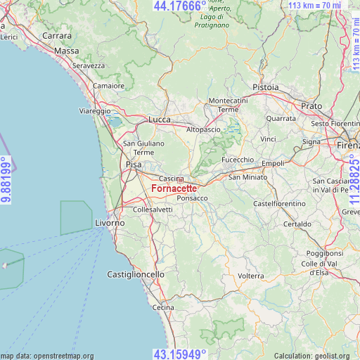
Fornacette GPS coordinates[2]
43° 40' 12.828" North, 10° 35' 6.432" East
| Map corner | latitude | longitude |
|---|---|---|
| Upper-left | 44.17666°, | 9.88199° |
| Center: | 43.67023°, | 10.58512° |
| Lower-right: | 43.15949°, | 11.28825° |
| Map W x H: | 113.1×113.1 km | = 70.3×70.3mi |
| max Lat: | 47.04031° ⇑58.4% North |
| Fornacette: | 43.67023° |
| min Lat: | ⇓41.6% South 35.50142° |
| min Long | Fornacette | max Long |
| 6.69888° | 10.58512° | 18.48682° |
| W 38%⇐ | ⇒62% E |
Elevation
Elevation of Fornacette is 13 m = 43 ft, and this is 293.7 m = 964 ft below average elevation for this country.
| Max E: |
2085 m = 6841 ft | 92.6% |
| Avg. | 306.7 m = 1006 ft | |
| Fornacette | 13 m = 43 ft | |
Min E: |
-4 m = -13 ft | 7.4% |
See also: Italy elevation on elevation.city.
Geographical zone
Fornacette is located in North temperate zone (between Tropic of Cancer and the Arctic Circle). Distance of this Northern Tropic circle is 2249.8 km =1398 mi to South.| Distance of | km | miles | from Fornacette |
|---|---|---|---|
| North Pole | 5151.4 | 3200.9 | to North |
| Arctic Circle | 2545.5 | 1581.7 | to North |
| Tropic Cancer | 2249.8 | 1398 | to South |
| Equator | 4855.7 | 3017.2 | to South |


Nearby cities:
15 places around Fornacette: (largest is in red/bold)
• Bientina
5.1 km =3.2 mi,  34°
34°
• Buti
6.5 km =4 mi,  359°
359°
• Calcinaia
2.9 km =1.8 mi,  59°
59°
• Cascina
2.5 km =1.6 mi,  283°
283°
• Chiesino-Collodi
2.3 km =1.4 mi, 63°
• Il Romito
5.4 km =3.4 mi,  115°
115°
• La Borra
4.7 km =2.9 mi,  130°
130°
• Latignano
2.7 km =1.7 mi,  229°
229°
• Lavaiano
4.5 km =2.8 mi,  180°
180°
• Ponsacco
6.2 km =3.9 mi,  147°
147°
• Pontedera
3.8 km =2.4 mi,  104°
104°
• Santa Lucia
3.6 km =2.2 mi,  143°
143°
• Uliveto Terme
6.2 km =3.9 mi,  297°
297°
• Val di Cava
6.2 km =3.9 mi, 124°
• Vicopisano
2.5 km =1.6 mi, 357°
Sources, notices
• [Note1] Compared only with cities in Italy existing in our database
• [Src1] Map data: © OpenStreetMap contributors (CC-BY-SA)
• [Src2] Other city data from geonames.org with taken over terms of usage.
• [Src3] Geographical zone / Annual Mean Temperature by Robert A. Rohde @ Wikipedia
