Gabella geodata
Gabella (Tuscany) is a populated place; located in Italy in Europe/Rome (GMT+2) time zone. With population of 1,196 people, there are 5971 cities with bigger population in this country. Compared to other cities in Italy, 57.8% of cities are located further ↑North; 62.9% of cities are located further →East and 94.8% of cities have higher elevation than Gabella. Note1


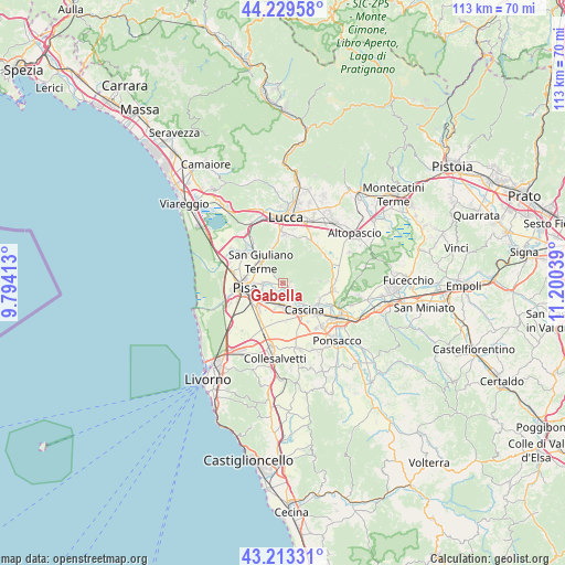
Gabella GPS coordinates[2]
43° 43' 24.96" North, 10° 29' 50.136" East
| Map corner | latitude | longitude |
|---|---|---|
| Upper-left | 44.22958°, | 9.79413° |
| Center: | 43.7236°, | 10.49726° |
| Lower-right: | 43.21331°, | 11.20039° |
| Map W x H: | 113×113 km | = 70.2×70.2mi |
| max Lat: | 47.04031° ⇑57.8% North |
| Gabella: | 43.7236° |
| min Lat: | ⇓42.2% South 35.50142° |
| min Long | Gabella | max Long |
| 6.69888° | 10.49726° | 18.48682° |
| W 37.1%⇐ | ⇒62.9% E |
Elevation
Elevation of Gabella is 9 m = 30 ft, and this is 297.7 m = 977 ft below average elevation for this country.
| Max E: |
2085 m = 6841 ft | 94.8% |
| Avg. | 306.7 m = 1006 ft | |
| Gabella | 9 m = 30 ft | |
Min E: |
-4 m = -13 ft | 5.2% |
See also: Italy elevation on elevation.city.
Geographical zone
Gabella is located in North temperate zone (between Tropic of Cancer and the Arctic Circle). Distance of this Northern Tropic circle is 2255.7 km =1401.6 mi to South.| Distance of | km | miles | from Gabella |
|---|---|---|---|
| North Pole | 5145.5 | 3197.3 | to North |
| Arctic Circle | 2539.6 | 1578 | to North |
| Tropic Cancer | 2255.7 | 1401.6 | to South |
| Equator | 4861.6 | 3020.9 | to South |


Nearby cities:
15 places around Gabella: (largest is in red/bold)
• Asciano
4 km =2.5 mi,  320°
320°
• Buti
7 km =4.3 mi,  85°
85°
• Calci
1.7 km =1.1 mi,  80°
80°
• Campo
2.4 km =1.5 mi,  223°
223°
• Caprona
1.8 km =1.1 mi,  160°
160°
• Cascina
7.1 km =4.4 mi,  139°
139°
• Fornacette
9.2 km =5.7 mi,  130°
130°
• Gello
6.8 km =4.2 mi,  299°
299°
• Latignano
9.2 km =5.7 mi,  146°
146°
• Orzignano
8.1 km =5 mi,  313°
313°
• Pisa
7.7 km =4.8 mi,  257°
257°
• Pontasserchio
9 km =5.6 mi, 313°
• San Giuliano Terme
6.5 km =4 mi, 313°
• Uliveto Terme
3.5 km =2.2 mi, 152°
• Vicopisano
7.7 km =4.8 mi,  116°
116°
Sources, notices
• [Note1] Compared only with cities in Italy existing in our database
• [Src1] Map data: © OpenStreetMap contributors (CC-BY-SA)
• [Src2] Other city data from geonames.org with taken over terms of usage.
• [Src3] Geographical zone / Annual Mean Temperature by Robert A. Rohde @ Wikipedia
