Latignano geodata
Latignano (Tuscany) is a populated place; located in Italy in Europe/Rome (GMT+2) time zone. With population of 775 people, there are 7789 cities with bigger population in this country. Compared to other cities in Italy, 58.6% of cities are located further ↑North; 62.2% of cities are located further →East and 96.6% of cities have higher elevation than Latignano. Note1


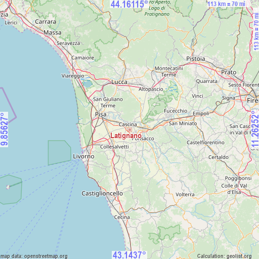
Latignano GPS coordinates[2]
43° 39' 16.488" North, 10° 33' 33.804" East
| Map corner | latitude | longitude |
|---|---|---|
| Upper-left | 44.16115°, | 9.85627° |
| Center: | 43.65458°, | 10.55939° |
| Lower-right: | 43.1437°, | 11.26252° |
| Map W x H: | 113.1×113.1 km | = 70.3×70.3mi |
| max Lat: | 47.04031° ⇑58.6% North |
| Latignano: | 43.65458° |
| min Lat: | ⇓41.4% South 35.50142° |
| min Long | Latignano | max Long |
| 6.69888° | 10.55939° | 18.48682° |
| W 37.8%⇐ | ⇒62.2% E |
Elevation
Elevation of Latignano is 6 m = 20 ft, and this is 300.7 m = 987 ft below average elevation for this country.
| Max E: |
2085 m = 6841 ft | 96.6% |
| Avg. | 306.7 m = 1006 ft | |
| Latignano | 6 m = 20 ft | |
Min E: |
-4 m = -13 ft | 3.4% |
See also: Italy elevation on elevation.city.
Geographical zone
Latignano is located in North temperate zone (between Tropic of Cancer and the Arctic Circle). Distance of this Northern Tropic circle is 2248 km =1396.8 mi to South.| Distance of | km | miles | from Latignano |
|---|---|---|---|
| North Pole | 5153.1 | 3202 | to North |
| Arctic Circle | 2547.2 | 1582.8 | to North |
| Tropic Cancer | 2248 | 1396.8 | to South |
| Equator | 4853.9 | 3016.1 | to South |


Nearby cities:
15 places around Latignano: (largest is in red/bold)
• Calcinaia
5.6 km =3.5 mi,  55°
55°
• Cascina
2.4 km =1.5 mi,  351°
351°
• Cenaia
5.7 km =3.5 mi,  199°
199°
• Chiesino-Collodi
5 km =3.1 mi, 56°
• Fornacette
2.7 km =1.7 mi,  49°
49°
• Il Romito
6.9 km =4.3 mi,  95°
95°
• La Borra
5.8 km =3.6 mi, 103°
• Lavaiano
3.4 km =2.1 mi,  144°
144°
• Le Casine-Perignano-Spinelli
6.4 km =4 mi,  162°
162°
• Ponsacco
6.4 km =4 mi,  122°
122°
• Pontedera
5.8 km =3.6 mi,  82°
82°
• Quattro Strade
5.6 km =3.5 mi,  170°
170°
• Santa Lucia
4.4 km =2.7 mi,  105°
105°
• Uliveto Terme
5.7 km =3.5 mi,  323°
323°
• Vicopisano
4.7 km =2.9 mi,  24°
24°
Sources, notices
• [Note1] Compared only with cities in Italy existing in our database
• [Src1] Map data: © OpenStreetMap contributors (CC-BY-SA)
• [Src2] Other city data from geonames.org with taken over terms of usage.
• [Src3] Geographical zone / Annual Mean Temperature by Robert A. Rohde @ Wikipedia
