Brebbia geodata
Brebbia (Lombardy) is a seat of a third-order administrative division; located in Italy in Europe/Rome (GMT+2) time zone. With population of 3,063 people, there are 2989 cities with bigger population in this country. Compared to other cities in Italy, 87.1% of cities are located further ↓South; 86.1% of cities are located further →East and 52.3% of cities have higher elevation than Brebbia. Note1


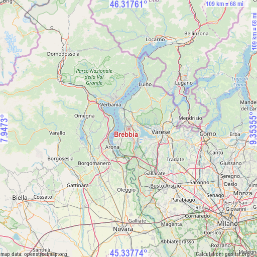
Brebbia GPS coordinates[2]
45° 49' 47.388" North, 8° 39' 1.512" East
| Map corner | latitude | longitude |
|---|---|---|
| Upper-left | 46.31761°, | 7.9473° |
| Center: | 45.82983°, | 8.65042° |
| Lower-right: | 45.33774°, | 9.35355° |
| Map W x H: | 109×108.9 km | = 67.7×67.7mi |
| max Lat: | 47.04031° ⇑12.9% North |
| Brebbia: | 45.82983° |
| min Lat: | ⇓87.1% South 35.50142° |
| min Long | Brebbia | max Long |
| 6.69888° | 8.65042° | 18.48682° |
| W 13.9%⇐ | ⇒86.1% E |
Elevation
Elevation of Brebbia is 220 m = 722 ft, and this is 86.7 m = 284 ft below average elevation for this country.
| Max E: |
2085 m = 6841 ft | 52.3% |
| Avg. | 306.7 m = 1006 ft | |
| Brebbia | 220 m = 722 ft | |
Min E: |
-4 m = -13 ft | 47.7% |
See also: Italy elevation on elevation.city.
Geographical zone
Brebbia is located in North temperate zone (between Tropic of Cancer and the Arctic Circle). Distance of this North polar circle is 2305.4 km =1432.5 mi to North.| Distance of | km | miles | from Brebbia |
|---|---|---|---|
| North Pole | 4911.3 | 3051.7 | to North |
| Arctic Circle | 2305.4 | 1432.5 | to North |
| Tropic Cancer | 2489.9 | 1547.2 | to South |
| Equator | 5095.8 | 3166.4 | to South |


Nearby cities:
15 places around Brebbia: (largest is in red/bold)
• Bardello
3.7 km =2.3 mi,  79°
79°
• Besozzo
2.4 km =1.5 mi,  28°
28°
• Biandronno
4.9 km =3 mi,  112°
112°
• Bregano
2.9 km =1.8 mi,  98°
98°
• Cadrezzate
3.4 km =2.1 mi,  189°
189°
• Caldana
5.7 km =3.5 mi,  35°
35°
• Caravate
5.4 km =3.4 mi,  3°
3°
• Cocquio
4.7 km =2.9 mi, 38°
• Ispra
3.4 km =2.1 mi,  240°
240°
• Leggiuno
5.6 km =3.5 mi,  335°
335°
• Malgesso
2 km =1.2 mi, 96°
• Monvalle
3.5 km =2.2 mi,  334°
334°
• Osmate
4.6 km =2.9 mi,  175°
175°
• Sangiano
5.2 km =3.2 mi,  345°
345°
• Travedona Monate
3.3 km =2.1 mi,  150°
150°
Sources, notices
• [Note1] Compared only with cities in Italy existing in our database
• [Src1] Map data: © OpenStreetMap contributors (CC-BY-SA)
• [Src2] Other city data from geonames.org with taken over terms of usage.
• [Src3] Geographical zone / Annual Mean Temperature by Robert A. Rohde @ Wikipedia
