Caravate geodata
Caravate (Lombardy) is a seat of a third-order administrative division; located in Italy in Europe/Rome (GMT+2) time zone. With population of 2,530 people, there are 3495 cities with bigger population in this country. Compared to other cities in Italy, 88.5% of cities are located further ↓South; 86.1% of cities are located further →East and 53.4% of cities have lower elevation than Caravate. Note1


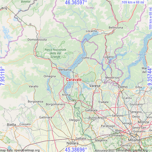
Caravate GPS coordinates[2]
45° 52' 43.032" North, 8° 39' 15.516" East
| Map corner | latitude | longitude |
|---|---|---|
| Upper-left | 46.36597°, | 7.95119° |
| Center: | 45.87862°, | 8.65431° |
| Lower-right: | 45.38696°, | 9.35744° |
| Map W x H: | 108.9×108.9 km | = 67.7×67.7mi |
| max Lat: | 47.04031° ⇑11.5% North |
| Caravate: | 45.87862° |
| min Lat: | ⇓88.5% South 35.50142° |
| min Long | Caravate | max Long |
| 6.69888° | 8.65431° | 18.48682° |
| W 13.9%⇐ | ⇒86.1% E |
Elevation
Elevation of Caravate is 255 m = 837 ft, and this is 51.7 m = 170 ft below average elevation for this country.
| Max E: |
2085 m = 6841 ft | 46.6% |
| Avg. | 306.7 m = 1006 ft | |
| Caravate | 255 m = 837 ft | |
Min E: |
-4 m = -13 ft | 53.4% |
See also: Italy elevation on elevation.city.
Geographical zone
Caravate is located in North temperate zone (between Tropic of Cancer and the Arctic Circle). Distance of this North polar circle is 2299.9 km =1429.1 mi to North.| Distance of | km | miles | from Caravate |
|---|---|---|---|
| North Pole | 4905.8 | 3048.3 | to North |
| Arctic Circle | 2299.9 | 1429.1 | to North |
| Tropic Cancer | 2495.3 | 1550.5 | to South |
| Equator | 5101.2 | 3169.7 | to South |


Nearby cities:
15 places around Caravate: (largest is in red/bold)
• Azzio
4.3 km =2.7 mi,  80°
80°
• Bardello
5.8 km =3.6 mi,  145°
145°
• Besozzo
3.4 km =2.1 mi,  165°
165°
• Brebbia
5.4 km =3.4 mi,  183°
183°
• Brenta
2.9 km =1.8 mi,  52°
52°
• Caldana
3.1 km =1.9 mi,  105°
105°
• Casalzuigno
5.1 km =3.2 mi,  55°
55°
• Cittiglio
2.1 km =1.3 mi,  24°
24°
• Cocquio
3.2 km =2 mi,  123°
123°
• Gemonio
1.6 km =1 mi,  89°
89°
• Laveno
4.3 km =2.7 mi,  322°
322°
• Leggiuno
2.6 km =1.6 mi,  263°
263°
• Monvalle
2.9 km =1.8 mi,  218°
218°
• Orino
4.8 km =3 mi, 86°
• Sangiano
1.7 km =1.1 mi, 256°
Sources, notices
• [Note1] Compared only with cities in Italy existing in our database
• [Src1] Map data: © OpenStreetMap contributors (CC-BY-SA)
• [Src2] Other city data from geonames.org with taken over terms of usage.
• [Src3] Geographical zone / Annual Mean Temperature by Robert A. Rohde @ Wikipedia
