Bovegno geodata
Bovegno (Lombardy) is a seat of a third-order administrative division; located in Italy in Europe/Rome (GMT+2) time zone. With population of 1,338 people, there are 5515 cities with bigger population in this country. Compared to other cities in Italy, 85.4% of cities are located further ↓South; 65.3% of cities are located further →East and 85.2% of cities have lower elevation than Bovegno. Note1


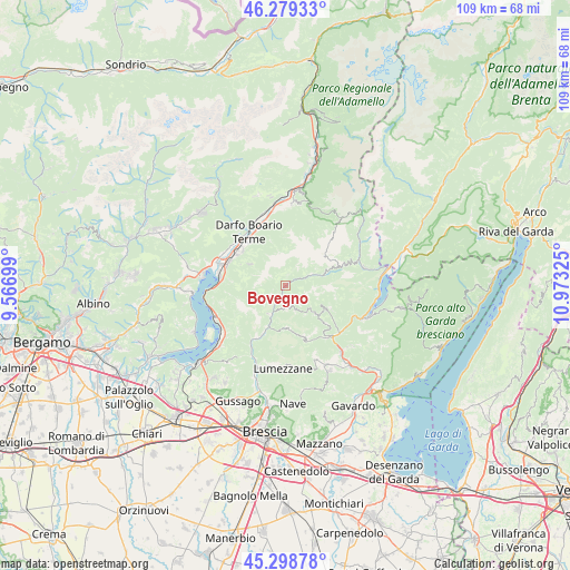
Bovegno GPS coordinates[2]
45° 47' 28.356" North, 10° 16' 12.432" East
| Map corner | latitude | longitude |
|---|---|---|
| Upper-left | 46.27933°, | 9.56699° |
| Center: | 45.79121°, | 10.27012° |
| Lower-right: | 45.29878°, | 10.97325° |
| Map W x H: | 109×109 km | = 67.7×67.7mi |
| max Lat: | 47.04031° ⇑14.6% North |
| Bovegno: | 45.79121° |
| min Lat: | ⇓85.4% South 35.50142° |
| min Long | Bovegno | max Long |
| 6.69888° | 10.27012° | 18.48682° |
| W 34.7%⇐ | ⇒65.3% E |
Elevation
Elevation of Bovegno is 617 m = 2024 ft, and this is 310.3 m = 1018 ft above average elevation for this country.
| Max E: |
2085 m = 6841 ft | 14.8% |
| Bovegno | 617 m 2024 ft | |
| Avg. | 306.7 m = 1006 ft | |
Min E: |
-4 m = -13 ft | 85.2% |
See also: Italy elevation on elevation.city.
Geographical zone
Bovegno is located in North temperate zone (between Tropic of Cancer and the Arctic Circle). Distance of this North polar circle is 2309.7 km =1435.2 mi to North.| Distance of | km | miles | from Bovegno |
|---|---|---|---|
| North Pole | 4915.6 | 3054.4 | to North |
| Arctic Circle | 2309.7 | 1435.2 | to North |
| Tropic Cancer | 2485.6 | 1544.5 | to South |
| Equator | 5091.5 | 3163.7 | to South |


Nearby cities:
15 places around Bovegno: (largest is in red/bold)
• Briale
10.4 km =6.5 mi,  159°
159°
• Brozzo
8.5 km =5.3 mi,  201°
201°
• Collio
5.5 km =3.4 mi,  66°
66°
• Dosso-Ville
4.3 km =2.7 mi,  176°
176°
• Irma
2.5 km =1.6 mi,  153°
153°
• Lodrino
8 km =5 mi, 175°
• Marmentino
4.2 km =2.6 mi, 164°
• Mura
10.3 km =6.4 mi, 147°
• Pertica Alta
7.9 km =4.9 mi,  133°
133°
• Pertica Bassa
9 km =5.6 mi,  117°
117°
• Pezzaze
3.1 km =1.9 mi,  237°
237°
• San Colombano
8.1 km =5 mi, 72°
• Stravignino
3.1 km =1.9 mi,  233°
233°
• Tavernole
5.5 km =3.4 mi,  205°
205°
• Villa
8.1 km =5 mi, 175°
Sources, notices
• [Note1] Compared only with cities in Italy existing in our database
• [Src1] Map data: © OpenStreetMap contributors (CC-BY-SA)
• [Src2] Other city data from geonames.org with taken over terms of usage.
• [Src3] Geographical zone / Annual Mean Temperature by Robert A. Rohde @ Wikipedia
