Borutta geodata
Borutta (Sardinia) is a seat of a third-order administrative division; located in Italy in Europe/Rome (GMT+2) time zone. With population of 273 people, there are 10789 cities with bigger population in this country. Compared to other cities in Italy, 84% of cities are located further ↑North; 84.9% of cities are located further →East and 77.3% of cities have lower elevation than Borutta. Note1


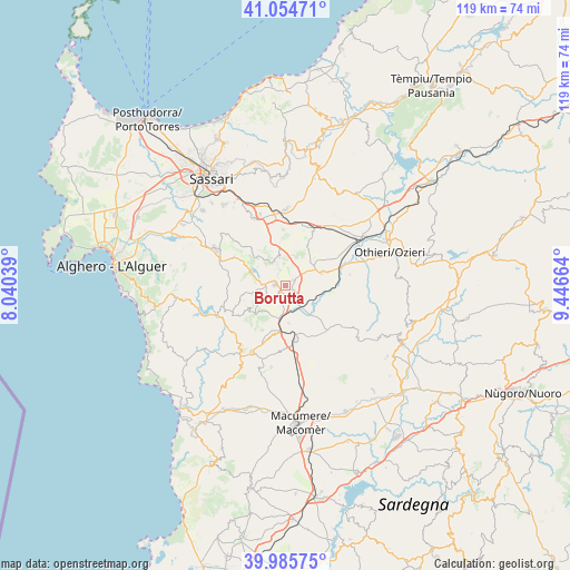
Borutta GPS coordinates[2]
40° 31' 20.496" North, 8° 44' 36.672" East
| Map corner | latitude | longitude |
|---|---|---|
| Upper-left | 41.05471°, | 8.04039° |
| Center: | 40.52236°, | 8.74352° |
| Lower-right: | 39.98575°, | 9.44664° |
| Map W x H: | 118.9×118.9 km | = 73.9×73.9mi |
| max Lat: | 47.04031° ⇑84% North |
| Borutta: | 40.52236° |
| min Lat: | ⇓16% South 35.50142° |
| min Long | Borutta | max Long |
| 6.69888° | 8.74352° | 18.48682° |
| W 15.1%⇐ | ⇒84.9% E |
Elevation
Elevation of Borutta is 484 m = 1588 ft, and this is 177.3 m = 582 ft above average elevation for this country.
| Max E: |
2085 m = 6841 ft | 22.7% |
| Borutta | 484 m 1588 ft | |
| Avg. | 306.7 m = 1006 ft | |
Min E: |
-4 m = -13 ft | 77.3% |
See also: Italy elevation on elevation.city.
Geographical zone
Borutta is located in North temperate zone (between Tropic of Cancer and the Arctic Circle). Distance of this Northern Tropic circle is 1899.7 km =1180.4 mi to South.| Distance of | km | miles | from Borutta |
|---|---|---|---|
| North Pole | 5501.4 | 3418.4 | to North |
| Arctic Circle | 2895.5 | 1799.2 | to North |
| Tropic Cancer | 1899.7 | 1180.4 | to South |
| Equator | 4505.7 | 2799.7 | to South |


Nearby cities:
15 places around Borutta: (largest is in red/bold)
• Ardara
12.4 km =7.7 mi,  26°
26°
• Banari
6.5 km =4 mi,  325°
325°
• Bessude
3.8 km =2.4 mi,  339°
339°
• Bonnanaro
2.1 km =1.3 mi,  56°
56°
• Bonorva
11.7 km =7.3 mi,  169°
169°
• Cheremule
2.5 km =1.6 mi,  217°
217°
• Cossoine
10.5 km =6.5 mi,  192°
192°
• Giave
7.8 km =4.8 mi, 174°
• Ittireddu
13.5 km =8.4 mi,  79°
79°
• Mores
8.1 km =5 mi,  69°
69°
• Romana
14 km =8.7 mi,  252°
252°
• Semestene
13.9 km =8.6 mi, 186°
• Siligo
6 km =3.7 mi,  347°
347°
• Thiesi
2 km =1.2 mi,  275°
275°
• Torralba
2.1 km =1.3 mi,  119°
119°
Sources, notices
• [Note1] Compared only with cities in Italy existing in our database
• [Src1] Map data: © OpenStreetMap contributors (CC-BY-SA)
• [Src2] Other city data from geonames.org with taken over terms of usage.
• [Src3] Geographical zone / Annual Mean Temperature by Robert A. Rohde @ Wikipedia
