Borgorose geodata
Borgorose (Latium) is a seat of a third-order administrative division; located in Italy in Europe/Rome (GMT+2) time zone. With population of 824 people, there are 7530 cities with bigger population in this country. Compared to other cities in Italy, 68.8% of cities are located further ↑North; 70.7% of cities are located further ←West and 89.9% of cities have lower elevation than Borgorose. Note1


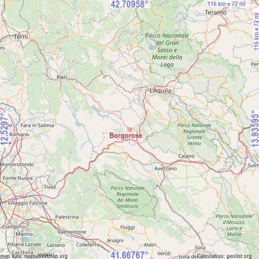
Borgorose GPS coordinates[2]
42° 11' 26.772" North, 13° 13' 58.152" East
| Map corner | latitude | longitude |
|---|---|---|
| Upper-left | 42.70958°, | 12.5297° |
| Center: | 42.19077°, | 13.23282° |
| Lower-right: | 41.66767°, | 13.93595° |
| Map W x H: | 115.8×115.8 km | = 72×72mi |
| max Lat: | 47.04031° ⇑68.8% North |
| Borgorose: | 42.19077° |
| min Lat: | ⇓31.2% South 35.50142° |
| min Long | Borgorose | max Long |
| 6.69888° | 13.23282° | 18.48682° |
| W 70.7%⇐ | ⇒29.3% E |
Elevation
Elevation of Borgorose is 719 m = 2359 ft, and this is 412.3 m = 1353 ft above average elevation for this country.
| Max E: |
2085 m = 6841 ft | 10.1% |
| Borgorose | 719 m 2359 ft | |
| Avg. | 306.7 m = 1006 ft | |
Min E: |
-4 m = -13 ft | 89.9% |
See also: Italy elevation on elevation.city.
Geographical zone
Borgorose is located in North temperate zone (between Tropic of Cancer and the Arctic Circle). Distance of this Northern Tropic circle is 2085.3 km =1295.7 mi to South.| Distance of | km | miles | from Borgorose |
|---|---|---|---|
| North Pole | 5315.9 | 3303.1 | to North |
| Arctic Circle | 2710 | 1683.9 | to North |
| Tropic Cancer | 2085.3 | 1295.7 | to South |
| Equator | 4691.2 | 2915 | to South |


Nearby cities:
15 places around Borgorose: (largest is in red/bold)
• Carsoli
15.7 km =9.8 mi,  229°
229°
• Collegiove
16.1 km =10 mi,  263°
263°
• Corvaro
3.1 km =1.9 mi,  58°
58°
• Fiamignano
12.2 km =7.6 mi,  312°
312°
• Lucoli
14.1 km =8.8 mi,  37°
37°
• Magliano De'Marsi
15.4 km =9.6 mi,  135°
135°
• Marcetelli
15.9 km =9.9 mi,  284°
284°
• Nespolo
14 km =8.7 mi,  254°
254°
• Pescorocchiano
7.3 km =4.5 mi, 283°
• San Nicola
12.9 km =8 mi,  15°
15°
• Sante Marie
10 km =6.2 mi,  194°
194°
• Tagliacozzo
13.6 km =8.5 mi,  172°
172°
• Torano
4.7 km =2.9 mi,  151°
151°
• Tornimparte
12.4 km =7.7 mi,  26°
26°
• Villagrande
12.9 km =8 mi, 25°
Sources, notices
• [Note1] Compared only with cities in Italy existing in our database
• [Src1] Map data: © OpenStreetMap contributors (CC-BY-SA)
• [Src2] Other city data from geonames.org with taken over terms of usage.
• [Src3] Geographical zone / Annual Mean Temperature by Robert A. Rohde @ Wikipedia
