Borgonovo Valtidone geodata
Borgonovo Valtidone (Emilia-Romagna) is a seat of a third-order administrative division; located in Italy in Europe/Rome (GMT+2) time zone. With population of 5,777 people, there are 1702 cities with bigger population in this country. Compared to other cities in Italy, 60.3% of cities are located further ↓South; 74% of cities are located further →East and 67.8% of cities have higher elevation than Borgonovo Valtidone. Note1
Administrative division(s):
- Level 1: Emilia-Romagna
- Level 2: Provincia di Piacenza
- Level 3: Borgonovo Val Tidone


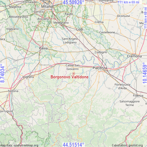
Borgonovo Valtidone GPS coordinates[2]
45° 0' 51.696" North, 9° 26' 36.456" East
| Map corner | latitude | longitude |
|---|---|---|
| Upper-left | 45.50926°, | 8.74034° |
| Center: | 45.01436°, | 9.44346° |
| Lower-right: | 44.51514°, | 10.14659° |
| Map W x H: | 110.5×110.5 km | = 68.7×68.7mi |
| max Lat: | 47.04031° ⇑39.7% North |
| Borgonovo Valtidone: | 45.01436° |
| min Lat: | ⇓60.3% South 35.50142° |
| min Long | Borgonovo Valti | max Long |
| 6.69888° | 9.44346° | 18.48682° |
| W 26%⇐ | ⇒74% E |
Elevation
Elevation of Borgonovo Valtidone is 110 m = 361 ft, and this is 196.7 m = 645 ft below average elevation for this country.
| Max E: |
2085 m = 6841 ft | 67.8% |
| Avg. | 306.7 m = 1006 ft | |
| Borgonovo Valtidone | 110 m = 361 ft | |
Min E: |
-4 m = -13 ft | 32.2% |
See also: Italy elevation on elevation.city.
Geographical zone
Borgonovo Valtidone is located in North temperate zone (between Tropic of Cancer and the Arctic Circle). Distance of this North polar circle is 2396 km =1488.8 mi to North.| Distance of | km | miles | from Borgonovo Valtidone |
|---|---|---|---|
| North Pole | 5001.9 | 3108 | to North |
| Arctic Circle | 2396 | 1488.8 | to North |
| Tropic Cancer | 2399.2 | 1490.8 | to South |
| Equator | 5005.1 | 3110 | to South |


Nearby cities:
15 places around Borgonovo Valtidone: (largest is in red/bold)
• Agazzano
9.5 km =5.9 mi,  141°
141°
• Bosnasco
8.8 km =5.5 mi,  309°
309°
• Castel San Giovanni
5.1 km =3.2 mi,  355°
355°
• Fontana Pradosa
5.5 km =3.4 mi,  16°
16°
• Gazzola
10.3 km =6.4 mi,  126°
126°
• Gragnano Trebbiense
10.1 km =6.3 mi,  91°
91°
• Montù Beccaria
10.6 km =6.6 mi,  283°
283°
• Pianello Val Tidone
8.1 km =5 mi,  201°
201°
• Rottofreno
9.5 km =5.9 mi,  61°
61°
• Rovescala
7.7 km =4.8 mi,  263°
263°
• San Damiano al Colle
7.6 km =4.7 mi, 280°
• Sarmato
6.3 km =3.9 mi,  41°
41°
• Trevozzo
8.1 km =5 mi,  207°
207°
• Zenevredo
10.2 km =6.3 mi,  295°
295°
• Ziano Piacentino
4.1 km =2.5 mi,  247°
247°
Sources, notices
• [Note1] Compared only with cities in Italy existing in our database
• [Src1] Map data: © OpenStreetMap contributors (CC-BY-SA)
• [Src2] Other city data from geonames.org with taken over terms of usage.
• [Src3] Geographical zone / Annual Mean Temperature by Robert A. Rohde @ Wikipedia
