Gazzola geodata
Gazzola (Emilia-Romagna) is a seat of a third-order administrative division; located in Italy in Europe/Rome (GMT+2) time zone. With population of 349 people, there are 10483 cities with bigger population in this country. Compared to other cities in Italy, 59.1% of cities are located further ↓South; 72.7% of cities are located further →East and 64% of cities have higher elevation than Gazzola. Note1


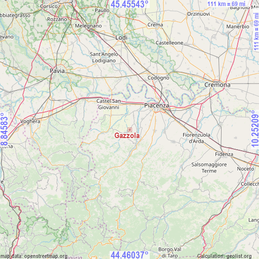
Gazzola GPS coordinates[2]
44° 57' 36.216" North, 9° 32' 56.256" East
| Map corner | latitude | longitude |
|---|---|---|
| Upper-left | 45.45543°, | 8.84583° |
| Center: | 44.96006°, | 9.54896° |
| Lower-right: | 44.46037°, | 10.25209° |
| Map W x H: | 110.6×110.6 km | = 68.7×68.7mi |
| max Lat: | 47.04031° ⇑40.9% North |
| Gazzola: | 44.96006° |
| min Lat: | ⇓59.1% South 35.50142° |
| min Long | Gazzola | max Long |
| 6.69888° | 9.54896° | 18.48682° |
| W 27.3%⇐ | ⇒72.7% E |
Elevation
Elevation of Gazzola is 134 m = 440 ft, and this is 172.7 m = 567 ft below average elevation for this country.
| Max E: |
2085 m = 6841 ft | 64% |
| Avg. | 306.7 m = 1006 ft | |
| Gazzola | 134 m = 440 ft | |
Min E: |
-4 m = -13 ft | 36% |
See also: Italy elevation on elevation.city.
Geographical zone
Gazzola is located in North temperate zone (between Tropic of Cancer and the Arctic Circle). Distance of this Northern Tropic circle is 2393.2 km =1487.1 mi to South.| Distance of | km | miles | from Gazzola |
|---|---|---|---|
| North Pole | 5008 | 3111.8 | to North |
| Arctic Circle | 2402.1 | 1492.6 | to North |
| Tropic Cancer | 2393.2 | 1487.1 | to South |
| Equator | 4999.1 | 3106.3 | to South |


Nearby cities:
15 places around Gazzola: (largest is in red/bold)
• Agazzano
2.8 km =1.7 mi,  239°
239°
• Borgonovo Valtidone
10.3 km =6.4 mi,  306°
306°
• Gossolengo
7.2 km =4.5 mi,  49°
49°
• Gragnano Trebbiense
6.1 km =3.8 mi,  16°
16°
• Niviano
6.7 km =4.2 mi,  109°
109°
• Pianello Val Tidone
11.4 km =7.1 mi,  262°
262°
• Piozzano
5.7 km =3.5 mi,  227°
227°
• Pittolo
10.8 km =6.7 mi,  56°
56°
• Podenzano
10.6 km =6.6 mi,  93°
93°
• Quarto
9.9 km =6.2 mi,  65°
65°
• Rivergaro
6.6 km =4.1 mi,  138°
138°
• Rottofreno
10.6 km =6.6 mi,  0°
0°
• Settima
8.4 km =5.2 mi,  80°
80°
• Travo
10.8 km =6.7 mi,  181°
181°
• Vigolzone
10.7 km =6.6 mi,  118°
118°
Sources, notices
• [Note1] Compared only with cities in Italy existing in our database
• [Src1] Map data: © OpenStreetMap contributors (CC-BY-SA)
• [Src2] Other city data from geonames.org with taken over terms of usage.
• [Src3] Geographical zone / Annual Mean Temperature by Robert A. Rohde @ Wikipedia
