Trevozzo geodata
Trevozzo (Emilia-Romagna) is a populated place; located in Italy in Europe/Rome (GMT+2) time zone. With population of 961 people, there are 6815 cities with bigger population in this country. Compared to other cities in Italy, 58.9% of cities are located further ↓South; 74.6% of cities are located further →East and 56.2% of cities have higher elevation than Trevozzo. Note1
Administrative division(s):
- Level 1: Emilia-Romagna
- Level 2: Provincia di Piacenza
- Level 3: Alta Val Tidone


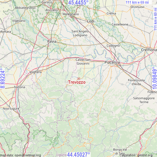
Trevozzo GPS coordinates[2]
44° 57' 0.144" North, 9° 23' 43.296" East
| Map corner | latitude | longitude |
|---|---|---|
| Upper-left | 45.4455°, | 8.69224° |
| Center: | 44.95004°, | 9.39536° |
| Lower-right: | 44.45027°, | 10.09849° |
| Map W x H: | 110.7×110.7 km | = 68.8×68.8mi |
| max Lat: | 47.04031° ⇑41.1% North |
| Trevozzo: | 44.95004° |
| min Lat: | ⇓58.9% South 35.50142° |
| min Long | Trevozzo | max Long |
| 6.69888° | 9.39536° | 18.48682° |
| W 25.4%⇐ | ⇒74.6% E |
Elevation
Elevation of Trevozzo is 194 m = 636 ft, and this is 112.7 m = 370 ft below average elevation for this country.
| Max E: |
2085 m = 6841 ft | 56.2% |
| Avg. | 306.7 m = 1006 ft | |
| Trevozzo | 194 m = 636 ft | |
Min E: |
-4 m = -13 ft | 43.8% |
See also: Italy elevation on elevation.city.
Geographical zone
Trevozzo is located in North temperate zone (between Tropic of Cancer and the Arctic Circle). Distance of this Northern Tropic circle is 2392.1 km =1486.4 mi to South.| Distance of | km | miles | from Trevozzo |
|---|---|---|---|
| North Pole | 5009.1 | 3112.5 | to North |
| Arctic Circle | 2403.2 | 1493.3 | to North |
| Tropic Cancer | 2392.1 | 1486.4 | to South |
| Equator | 4998 | 3105.6 | to South |


Nearby cities:
15 places around Trevozzo: (largest is in red/bold)
• Agazzano
9.7 km =6 mi,  91°
91°
• Borgonovo Valtidone
8.1 km =5 mi,  27°
27°
• Caminata
8.2 km =5.1 mi,  237°
237°
• Caseo
9.5 km =5.9 mi,  265°
265°
• Golferenzo
7.1 km =4.4 mi,  279°
279°
• Montecalvo Versiggia
9 km =5.6 mi,  285°
285°
• Nibbiano
7.3 km =4.5 mi,  226°
226°
• Pecorara
8.3 km =5.2 mi,  186°
186°
• Pianello Val Tidone
0.9 km =0.6 mi,  115°
115°
• Piozzano
8.4 km =5.2 mi,  109°
109°
• Rovescala
7.4 km =4.6 mi,  328°
328°
• San Damiano al Colle
9.3 km =5.8 mi,  336°
336°
• Santa Maria della Versa
8.6 km =5.3 mi,  299°
299°
• Volpara
7.7 km =4.8 mi, 273°
• Ziano Piacentino
5.5 km =3.4 mi,  359°
359°
Sources, notices
• [Note1] Compared only with cities in Italy existing in our database
• [Src1] Map data: © OpenStreetMap contributors (CC-BY-SA)
• [Src2] Other city data from geonames.org with taken over terms of usage.
• [Src3] Geographical zone / Annual Mean Temperature by Robert A. Rohde @ Wikipedia
