Roncofreddo geodata
Roncofreddo (Emilia-Romagna) is a seat of a third-order administrative division; located in Italy in Europe/Rome (GMT+2) time zone. With population of 2,819 people, there are 3195 cities with bigger population in this country. Compared to other cities in Italy, 54.3% of cities are located further ↑North; 59.9% of cities are located further ←West and 54.1% of cities have lower elevation than Roncofreddo. Note1
Administrative division(s):
- Level 1: Emilia-Romagna
- Level 2: Provincia di Forlì-Cesena
- Level 3: Roncofreddo


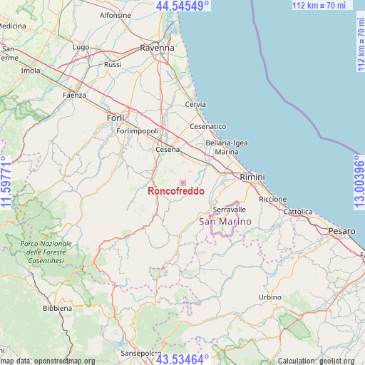
Roncofreddo GPS coordinates[2]
44° 2' 31.992" North, 12° 18' 2.988" East
| Map corner | latitude | longitude |
|---|---|---|
| Upper-left | 44.54549°, | 11.59771° |
| Center: | 44.04222°, | 12.30083° |
| Lower-right: | 43.53464°, | 13.00396° |
| Map W x H: | 112.4×112.4 km | = 69.8×69.8mi |
| max Lat: | 47.04031° ⇑54.3% North |
| Roncofreddo: | 44.04222° |
| min Lat: | ⇓45.7% South 35.50142° |
| min Long | Roncofreddo | max Long |
| 6.69888° | 12.30083° | 18.48682° |
| W 59.9%⇐ | ⇒40.1% E |
Elevation
Elevation of Roncofreddo is 260 m = 853 ft, and this is 46.7 m = 153 ft below average elevation for this country.
| Max E: |
2085 m = 6841 ft | 45.9% |
| Avg. | 306.7 m = 1006 ft | |
| Roncofreddo | 260 m = 853 ft | |
Min E: |
-4 m = -13 ft | 54.1% |
See also: Italy elevation on elevation.city.
Geographical zone
Roncofreddo is located in North temperate zone (between Tropic of Cancer and the Arctic Circle). Distance of this Northern Tropic circle is 2291.1 km =1423.6 mi to South.| Distance of | km | miles | from Roncofreddo |
|---|---|---|---|
| North Pole | 5110 | 3175.2 | to North |
| Arctic Circle | 2504.1 | 1556 | to North |
| Tropic Cancer | 2291.1 | 1423.6 | to South |
| Equator | 4897 | 3042.9 | to South |


Nearby cities:
15 places around Roncofreddo: (largest is in red/bold)
• Bora Bassa
9.6 km =6 mi,  272°
272°
• Borello
9.8 km =6.1 mi,  280°
280°
• Borghi
4.6 km =2.9 mi,  104°
104°
• Budrio
7.1 km =4.4 mi,  26°
26°
• Gambettola
8.9 km =5.5 mi,  19°
19°
• Gualdo
8 km =5 mi,  254°
254°
• Longiano
4.3 km =2.7 mi, 32°
• Montiano
4.5 km =2.8 mi,  3°
3°
• Poggio Berni
8.9 km =5.5 mi, 101°
• Roncofreddo-Santa Paola
1.2 km =0.7 mi,  88°
88°
• Sant'Andrea
9.5 km =5.9 mi, 96°
• Santo Marino
9 km =5.6 mi,  110°
110°
• Savignano sul Rubicone
9.5 km =5.9 mi,  55°
55°
• Sogliano al Rubicone
4.1 km =2.5 mi,  179°
179°
• Torriana
9.3 km =5.8 mi,  133°
133°
Sources, notices
• [Note1] Compared only with cities in Italy existing in our database
• [Src1] Map data: © OpenStreetMap contributors (CC-BY-SA)
• [Src2] Other city data from geonames.org with taken over terms of usage.
• [Src3] Geographical zone / Annual Mean Temperature by Robert A. Rohde @ Wikipedia
