Roncofreddo-Santa Paola geodata
Roncofreddo-Santa Paola (Emilia-Romagna) is a seat of a third-order administrative division; located in Italy in Europe/Rome (GMT+2) time zone. With population of 1,237 people, there are 5840 cities with bigger population in this country. Compared to other cities in Italy, 54.3% of cities are located further ↑North; 60.1% of cities are located further ←West and 60.2% of cities have lower elevation than Roncofreddo-Santa Paola. Note1
Administrative division(s):
- Level 1: Emilia-Romagna
- Level 2: Provincia di Forlì-Cesena
- Level 3: Roncofreddo
Current local time in Roncofreddo-Santa Paola:
10:13 PM, WednesdayDifference from your time zone: hours


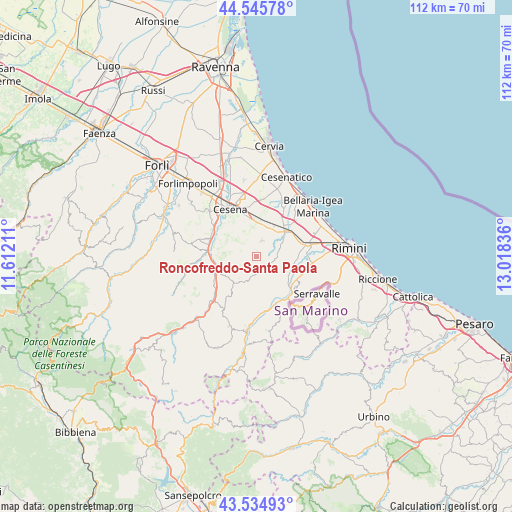
Roncofreddo-Santa Paola GPS coordinates[2]
44° 2' 33.036" North, 12° 18' 54.828" East
| Map corner | latitude | longitude |
|---|---|---|
| Upper-left | 44.54578°, | 11.61211° |
| Center: | 44.04251°, | 12.31523° |
| Lower-right: | 43.53493°, | 13.01836° |
| Map W x H: | 112.4×112.4 km | = 69.8×69.8mi |
| max Lat: | 47.04031° ⇑54.3% North |
| Roncofreddo-Santa Paola: | 44.04251° |
| min Lat: | ⇓45.7% South 35.50142° |
| min Long | Roncofreddo-San | max Long |
| 6.69888° | 12.31523° | 18.48682° |
| W 60.1%⇐ | ⇒39.9% E |
Elevation
Elevation of Roncofreddo-Santa Paola is 300 m = 984 ft, and this is 6.7 m = 22 ft below average elevation for this country.
| Max E: |
2085 m = 6841 ft | 39.8% |
| Avg. | 306.7 m = 1006 ft | |
| Roncofreddo-Santa Paola | 300 m = 984 ft | |
Min E: |
-4 m = -13 ft | 60.2% |
See also: Italy elevation on elevation.city.
Geographical zone
Roncofreddo-Santa Paola is located in North temperate zone (between Tropic of Cancer and the Arctic Circle). Distance of this Northern Tropic circle is 2291.1 km =1423.6 mi to South.| Distance of | km | miles | from Roncofreddo-Santa Paola |
|---|---|---|---|
| North Pole | 5110 | 3175.2 | to North |
| Arctic Circle | 2504.1 | 1556 | to North |
| Tropic Cancer | 2291.1 | 1423.6 | to South |
| Equator | 4897.1 | 3042.9 | to South |


Nearby cities:
15 places around Roncofreddo-Santa Paola: (largest is in red/bold)
• Borghi
3.5 km =2.2 mi,  109°
109°
• Budrio
6.6 km =4.1 mi,  17°
17°
• Gambettola
8.5 km =5.3 mi,  11°
11°
• Gatteo-Sant'Angelo
9.8 km =6.1 mi,  38°
38°
• Gualdo
9.1 km =5.7 mi,  255°
255°
• Longiano
3.7 km =2.3 mi, 18°
• Montiano
4.5 km =2.8 mi,  349°
349°
• Poggio Berni
7.7 km =4.8 mi,  103°
103°
• Roncofreddo
1.2 km =0.7 mi,  268°
268°
• San Michele
9 km =5.6 mi,  91°
91°
• Sant'Andrea
8.4 km =5.2 mi, 97°
• Santo Marino
8 km =5 mi, 113°
• Savignano sul Rubicone
8.6 km =5.3 mi,  51°
51°
• Sogliano al Rubicone
4.3 km =2.7 mi,  195°
195°
• Torriana
8.5 km =5.3 mi,  138°
138°
Sources, notices
• [Note1] Compared only with cities in Italy existing in our database
• [Src1] Map data: © OpenStreetMap contributors (CC-BY-SA)
• [Src2] Other city data from geonames.org with taken over terms of usage.
• [Src3] Geographical zone / Annual Mean Temperature by Robert A. Rohde @ Wikipedia
