Caramanico Terme geodata
Caramanico Terme (Abruzzo) is a seat of a third-order administrative division; located in Italy in Europe/Rome (GMT+2) time zone. With population of 1,042 people, there are 6497 cities with bigger population in this country. Compared to other cities in Italy, 69% of cities are located further ↑North; 78.2% of cities are located further ←West and 85.8% of cities have lower elevation than Caramanico Terme. Note1
Administrative division(s):
- Level 1: Abruzzo
- Level 2: Provincia di Pescara
- Level 3: Caramanico Terme


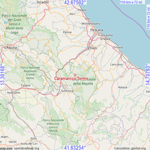
Caramanico Terme GPS coordinates[2]
42° 9' 21.348" North, 14° 0' 17.28" East
| Map corner | latitude | longitude |
|---|---|---|
| Upper-left | 42.67502°, | 13.30168° |
| Center: | 42.15593°, | 14.0048° |
| Lower-right: | 41.63254°, | 14.70793° |
| Map W x H: | 115.9×115.9 km | = 72×72mi |
| max Lat: | 47.04031° ⇑69% North |
| Caramanico Terme: | 42.15593° |
| min Lat: | ⇓31% South 35.50142° |
| min Long | Caramanico Term | max Long |
| 6.69888° | 14.0048° | 18.48682° |
| W 78.2%⇐ | ⇒21.8% E |
Elevation
Elevation of Caramanico Terme is 629 m = 2064 ft, and this is 322.3 m = 1057 ft above average elevation for this country.
| Max E: |
2085 m = 6841 ft | 14.2% |
| Caramanico Terme | 629 m 2064 ft | |
| Avg. | 306.7 m = 1006 ft | |
Min E: |
-4 m = -13 ft | 85.8% |
See also: Italy elevation on elevation.city.
Geographical zone
Caramanico Terme is located in North temperate zone (between Tropic of Cancer and the Arctic Circle). Distance of this Northern Tropic circle is 2081.4 km =1293.3 mi to South.| Distance of | km | miles | from Caramanico Terme |
|---|---|---|---|
| North Pole | 5319.8 | 3305.6 | to North |
| Arctic Circle | 2713.9 | 1686.3 | to North |
| Tropic Cancer | 2081.4 | 1293.3 | to South |
| Equator | 4687.3 | 2912.6 | to South |


Nearby cities:
15 places around Caramanico Terme: (largest is in red/bold)
• Abbateggio
7.6 km =4.7 mi,  3°
3°
• Badia
10.3 km =6.4 mi,  224°
224°
• Bolognano
7.8 km =4.8 mi,  331°
331°
• Lettomanoppello
10.1 km =6.3 mi,  15°
15°
• Marane
11.3 km =7 mi,  204°
204°
• Pacentro
11.8 km =7.3 mi,  185°
185°
• Roccacasale
10.4 km =6.5 mi,  248°
248°
• Roccamorice
6.5 km =4 mi,  14°
14°
• Salle
4.3 km =2.7 mi,  303°
303°
• San Valentino in Abruzzo Citeriore
8.7 km =5.4 mi,  349°
349°
• Sant'Eufemia a Maiella
3.8 km =2.4 mi,  151°
151°
• Scafa
12.2 km =7.6 mi,  356°
356°
• Tocco da Casauria
9.6 km =6 mi,  310°
310°
• Torre de' Passeri
11.4 km =7.1 mi, 328°
• Turrivalignani
12.1 km =7.5 mi, 9°
Sources, notices
• [Note1] Compared only with cities in Italy existing in our database
• [Src1] Map data: © OpenStreetMap contributors (CC-BY-SA)
• [Src2] Other city data from geonames.org with taken over terms of usage.
• [Src3] Geographical zone / Annual Mean Temperature by Robert A. Rohde @ Wikipedia
