Pietrelcina geodata
Pietrelcina (Campania) is a seat of a third-order administrative division; located in Italy in Europe/Rome (GMT+2) time zone. With population of 1,566 people, there are 4971 cities with bigger population in this country. Compared to other cities in Italy, 76.9% of cities are located further ↑North; 85.9% of cities are located further ←West and 68.4% of cities have lower elevation than Pietrelcina. Note1


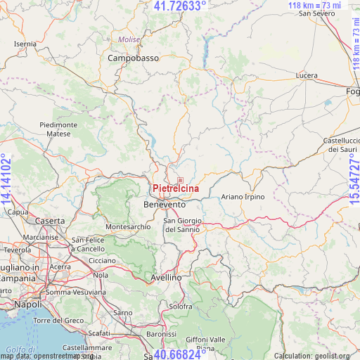
Pietrelcina GPS coordinates[2]
41° 11' 57.912" North, 14° 50' 38.904" East
| Map corner | latitude | longitude |
|---|---|---|
| Upper-left | 41.72633°, | 14.14102° |
| Center: | 41.19942°, | 14.84414° |
| Lower-right: | 40.66824°, | 15.54727° |
| Map W x H: | 117.6×117.6 km | = 73.1×73.1mi |
| max Lat: | 47.04031° ⇑76.9% North |
| Pietrelcina: | 41.19942° |
| min Lat: | ⇓23.1% South 35.50142° |
| min Long | Pietrelcina | max Long |
| 6.69888° | 14.84414° | 18.48682° |
| W 85.9%⇐ | ⇒14.1% E |
Elevation
Elevation of Pietrelcina is 377 m = 1237 ft, and this is 70.3 m = 231 ft above average elevation for this country.
| Max E: |
2085 m = 6841 ft | 31.6% |
| Pietrelcina | 377 m 1237 ft | |
| Avg. | 306.7 m = 1006 ft | |
Min E: |
-4 m = -13 ft | 68.4% |
See also: Italy elevation on elevation.city.
Geographical zone
Pietrelcina is located in North temperate zone (between Tropic of Cancer and the Arctic Circle). Distance of this Northern Tropic circle is 1975 km =1227.2 mi to South.| Distance of | km | miles | from Pietrelcina |
|---|---|---|---|
| North Pole | 5426.1 | 3371.6 | to North |
| Arctic Circle | 2820.2 | 1752.4 | to North |
| Tropic Cancer | 1975 | 1227.2 | to South |
| Equator | 4580.9 | 2846.4 | to South |


Nearby cities:
15 places around Pietrelcina: (largest is in red/bold)
• Apice Vecchio
11.4 km =7.1 mi,  140°
140°
• Benevento
9.4 km =5.8 mi,  215°
215°
• Buonalbergo
11.5 km =7.1 mi,  77°
77°
• Fragneto L'Abate
8 km =5 mi,  321°
321°
• Fragneto Monforte
8.5 km =5.3 mi,  307°
307°
• Iannassi-Bosco Perrotta
12.1 km =7.5 mi,  183°
183°
• Molinara
12.1 km =7.5 mi,  26°
26°
• Paduli
5 km =3.1 mi,  134°
134°
• Pago Veiano
5.1 km =3.2 mi,  20°
20°
• Pesco Sannita
4.6 km =2.9 mi, 323°
• Ponte
12.3 km =7.6 mi,  278°
278°
• Reino
10.5 km =6.5 mi,  350°
350°
• San Giorgio la Molara
11.2 km =7 mi,  40°
40°
• Sant'Arcangelo Trimonte
8.6 km =5.3 mi,  113°
113°
• Santa Colomba II
11.3 km =7 mi,  208°
208°
Sources, notices
• [Note1] Compared only with cities in Italy existing in our database
• [Src1] Map data: © OpenStreetMap contributors (CC-BY-SA)
• [Src2] Other city data from geonames.org with taken over terms of usage.
• [Src3] Geographical zone / Annual Mean Temperature by Robert A. Rohde @ Wikipedia
