Belgioioso geodata
Belgioioso (Lombardy) is a seat of a third-order administrative division; located in Italy in Europe/Rome (GMT+2) time zone. With population of 6,209 people, there are 1575 cities with bigger population in this country. Compared to other cities in Italy, 64% of cities are located further ↓South; 76.1% of cities are located further →East and 75.2% of cities have higher elevation than Belgioioso. Note1


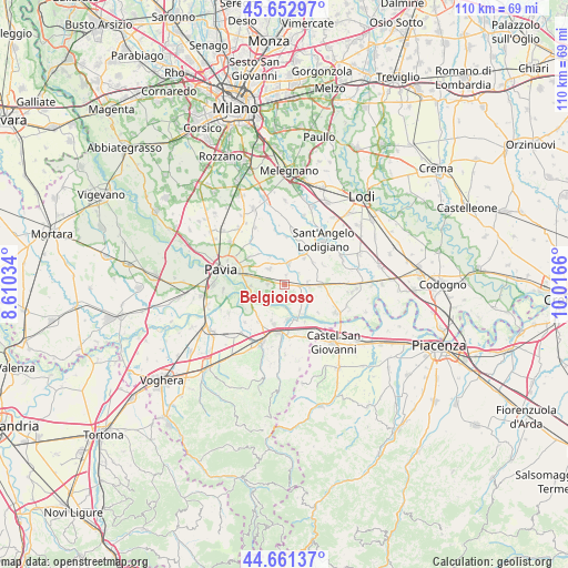
Belgioioso GPS coordinates[2]
45° 9' 33.588" North, 9° 18' 48.492" East
| Map corner | latitude | longitude |
|---|---|---|
| Upper-left | 45.65297°, | 8.61034° |
| Center: | 45.15933°, | 9.31347° |
| Lower-right: | 44.66137°, | 10.0166° |
| Map W x H: | 110.3×110.3 km | = 68.5×68.5mi |
| max Lat: | 47.04031° ⇑36% North |
| Belgioioso: | 45.15933° |
| min Lat: | ⇓64% South 35.50142° |
| min Long | Belgioioso | max Long |
| 6.69888° | 9.31347° | 18.48682° |
| W 23.9%⇐ | ⇒76.1% E |
Elevation
Elevation of Belgioioso is 73 m = 240 ft, and this is 233.7 m = 767 ft below average elevation for this country.
| Max E: |
2085 m = 6841 ft | 75.2% |
| Avg. | 306.7 m = 1006 ft | |
| Belgioioso | 73 m = 240 ft | |
Min E: |
-4 m = -13 ft | 24.8% |
See also: Italy elevation on elevation.city.
Geographical zone
Belgioioso is located in North temperate zone (between Tropic of Cancer and the Arctic Circle). Distance of this North polar circle is 2379.9 km =1478.8 mi to North.| Distance of | km | miles | from Belgioioso |
|---|---|---|---|
| North Pole | 4985.8 | 3098 | to North |
| Arctic Circle | 2379.9 | 1478.8 | to North |
| Tropic Cancer | 2415.3 | 1500.8 | to South |
| Equator | 5021.2 | 3120 | to South |


Nearby cities:
15 places around Belgioioso: (largest is in red/bold)
• Albuzzano
4.4 km =2.7 mi,  314°
314°
• Calignano
6.5 km =4 mi,  337°
337°
• Copiano
4.3 km =2.7 mi,  11°
11°
• Corteolona
4.6 km =2.9 mi,  92°
92°
• Costa de' Nobili
6 km =3.7 mi,  120°
120°
• Filighera
1.8 km =1.1 mi, 7°
• Genzone
3.5 km =2.2 mi,  50°
50°
• Gerenzago
6.4 km =4 mi,  35°
35°
• Linarolo
3.4 km =2.1 mi,  275°
275°
• San Cipriano Po
6.1 km =3.8 mi,  204°
204°
• Spessa
5.8 km =3.6 mi,  151°
151°
• Torre de' Negri
2 km =1.2 mi, 123°
• Valle Salimbene
6.4 km =4 mi, 282°
• Vigalfo
4.7 km =2.9 mi,  328°
328°
• Vistarino
5.7 km =3.5 mi,  355°
355°
Sources, notices
• [Note1] Compared only with cities in Italy existing in our database
• [Src1] Map data: © OpenStreetMap contributors (CC-BY-SA)
• [Src2] Other city data from geonames.org with taken over terms of usage.
• [Src3] Geographical zone / Annual Mean Temperature by Robert A. Rohde @ Wikipedia
