Filighera geodata
Filighera (Lombardy) is a seat of a third-order administrative division; located in Italy in Europe/Rome (GMT+2) time zone. With population of 775 people, there are 7789 cities with bigger population in this country. Compared to other cities in Italy, 64.4% of cities are located further ↓South; 76% of cities are located further →East and 75.2% of cities have higher elevation than Filighera. Note1


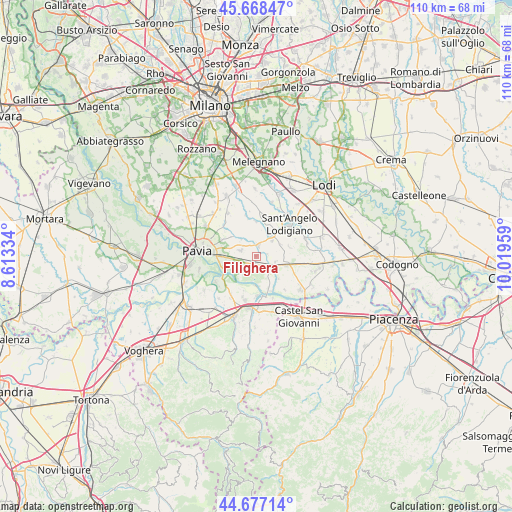
Filighera GPS coordinates[2]
45° 10' 29.856" North, 9° 18' 59.256" East
| Map corner | latitude | longitude |
|---|---|---|
| Upper-left | 45.66847°, | 8.61334° |
| Center: | 45.17496°, | 9.31646° |
| Lower-right: | 44.67714°, | 10.01959° |
| Map W x H: | 110.2×110.2 km | = 68.5×68.5mi |
| max Lat: | 47.04031° ⇑35.6% North |
| Filighera: | 45.17496° |
| min Lat: | ⇓64.4% South 35.50142° |
| min Long | Filighera | max Long |
| 6.69888° | 9.31646° | 18.48682° |
| W 24%⇐ | ⇒76% E |
Elevation
Elevation of Filighera is 73 m = 240 ft, and this is 233.7 m = 767 ft below average elevation for this country.
| Max E: |
2085 m = 6841 ft | 75.2% |
| Avg. | 306.7 m = 1006 ft | |
| Filighera | 73 m = 240 ft | |
Min E: |
-4 m = -13 ft | 24.8% |
See also: Italy elevation on elevation.city.
Geographical zone
Filighera is located in North temperate zone (between Tropic of Cancer and the Arctic Circle). Distance of this North polar circle is 2378.2 km =1477.7 mi to North.| Distance of | km | miles | from Filighera |
|---|---|---|---|
| North Pole | 4984.1 | 3097 | to North |
| Arctic Circle | 2378.2 | 1477.7 | to North |
| Tropic Cancer | 2417.1 | 1501.9 | to South |
| Equator | 5023 | 3121.1 | to South |


Nearby cities:
15 places around Filighera: (largest is in red/bold)
• Albuzzano
3.6 km =2.2 mi,  292°
292°
• Belgioioso
1.8 km =1.1 mi,  187°
187°
• Calignano
5 km =3.1 mi,  327°
327°
• Copiano
2.6 km =1.6 mi,  14°
14°
• Corteolona
4.8 km =3 mi,  113°
113°
• Genzone
2.5 km =1.6 mi,  78°
78°
• Gerenzago
5 km =3.1 mi,  45°
45°
• Inverno
5.9 km =3.7 mi,  63°
63°
• Inverno e Monteleone
6 km =3.7 mi, 64°
• Linarolo
3.9 km =2.4 mi,  248°
248°
• Magherno
5.5 km =3.4 mi, 10°
• Torre de' Negri
3.2 km =2 mi,  153°
153°
• Vigalfo
3.5 km =2.2 mi,  310°
310°
• Villanterio
5.9 km =3.7 mi,  36°
36°
• Vistarino
4 km =2.5 mi,  350°
350°
Sources, notices
• [Note1] Compared only with cities in Italy existing in our database
• [Src1] Map data: © OpenStreetMap contributors (CC-BY-SA)
• [Src2] Other city data from geonames.org with taken over terms of usage.
• [Src3] Geographical zone / Annual Mean Temperature by Robert A. Rohde @ Wikipedia
