Genzone geodata
Genzone (Lombardy) is a seat of a third-order administrative division; located in Italy in Europe/Rome (GMT+2) time zone. With population of 358 people, there are 10448 cities with bigger population in this country. Compared to other cities in Italy, 64.5% of cities are located further ↓South; 75.5% of cities are located further →East and 75.6% of cities have higher elevation than Genzone. Note1
Administrative division(s):
- Level 1: Lombardy
- Level 2: Provincia di Pavia
- Level 3: Corteolona e Genzone


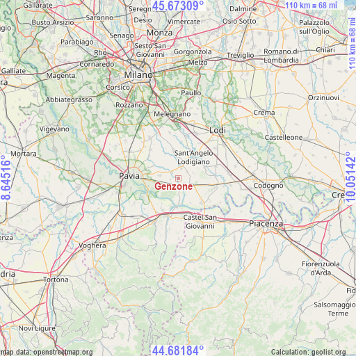
Genzone GPS coordinates[2]
45° 10' 46.632" North, 9° 20' 53.844" East
| Map corner | latitude | longitude |
|---|---|---|
| Upper-left | 45.67309°, | 8.64516° |
| Center: | 45.17962°, | 9.34829° |
| Lower-right: | 44.68184°, | 10.05142° |
| Map W x H: | 110.2×110.2 km | = 68.5×68.5mi |
| max Lat: | 47.04031° ⇑35.5% North |
| Genzone: | 45.17962° |
| min Lat: | ⇓64.5% South 35.50142° |
| min Long | Genzone | max Long |
| 6.69888° | 9.34829° | 18.48682° |
| W 24.5%⇐ | ⇒75.5% E |
Elevation
Elevation of Genzone is 71 m = 233 ft, and this is 235.7 m = 773 ft below average elevation for this country.
| Max E: |
2085 m = 6841 ft | 75.6% |
| Avg. | 306.7 m = 1006 ft | |
| Genzone | 71 m = 233 ft | |
Min E: |
-4 m = -13 ft | 24.4% |
See also: Italy elevation on elevation.city.
Geographical zone
Genzone is located in North temperate zone (between Tropic of Cancer and the Arctic Circle). Distance of this North polar circle is 2377.7 km =1477.4 mi to North.| Distance of | km | miles | from Genzone |
|---|---|---|---|
| North Pole | 4983.6 | 3096.7 | to North |
| Arctic Circle | 2377.7 | 1477.4 | to North |
| Tropic Cancer | 2417.6 | 1502.2 | to South |
| Equator | 5023.5 | 3121.5 | to South |


Nearby cities:
15 places around Genzone: (largest is in red/bold)
• Belgioioso
3.5 km =2.2 mi,  230°
230°
• Copiano
2.7 km =1.7 mi,  316°
316°
• Corteolona
3.1 km =1.9 mi,  142°
142°
• Costa de' Nobili
5.8 km =3.6 mi,  155°
155°
• Filighera
2.5 km =1.6 mi,  258°
258°
• Gerenzago
3.1 km =1.9 mi,  19°
19°
• Inverno
3.5 km =2.2 mi,  53°
53°
• Inverno e Monteleone
3.5 km =2.2 mi, 54°
• Magherno
5.1 km =3.2 mi,  343°
343°
• Monteleone
5 km =3.1 mi,  71°
71°
• Santa Cristina
4.7 km =2.9 mi,  121°
121°
• Torre de' Negri
3.5 km =2.2 mi,  197°
197°
• Vigalfo
5.5 km =3.4 mi,  288°
288°
• Villanterio
4.4 km =2.7 mi,  13°
13°
• Vistarino
4.7 km =2.9 mi, 317°
Sources, notices
• [Note1] Compared only with cities in Italy existing in our database
• [Src1] Map data: © OpenStreetMap contributors (CC-BY-SA)
• [Src2] Other city data from geonames.org with taken over terms of usage.
• [Src3] Geographical zone / Annual Mean Temperature by Robert A. Rohde @ Wikipedia
