Bastiglia geodata
Bastiglia (Emilia-Romagna) is a seat of a third-order administrative division; located in Italy in Europe/Rome (GMT+2) time zone. With population of 3,606 people, there are 2616 cities with bigger population in this country. Compared to other cities in Italy, 54.7% of cities are located further ↓South; 57.4% of cities are located further →East and 86.1% of cities have higher elevation than Bastiglia. Note1


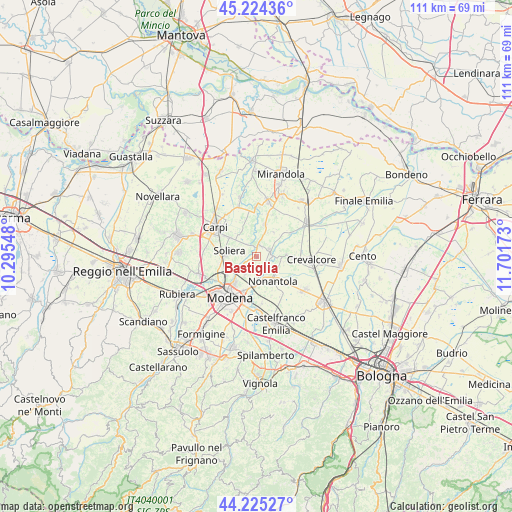
Bastiglia GPS coordinates[2]
44° 43' 37.092" North, 10° 59' 54.96" East
| Map corner | latitude | longitude |
|---|---|---|
| Upper-left | 45.22436°, | 10.29548° |
| Center: | 44.72697°, | 10.9986° |
| Lower-right: | 44.22527°, | 11.70173° |
| Map W x H: | 111.1×111.1 km | = 69×69mi |
| max Lat: | 47.04031° ⇑45.3% North |
| Bastiglia: | 44.72697° |
| min Lat: | ⇓54.7% South 35.50142° |
| min Long | Bastiglia | max Long |
| 6.69888° | 10.9986° | 18.48682° |
| W 42.6%⇐ | ⇒57.4% E |
Elevation
Elevation of Bastiglia is 28 m = 92 ft, and this is 278.7 m = 914 ft below average elevation for this country.
| Max E: |
2085 m = 6841 ft | 86.1% |
| Avg. | 306.7 m = 1006 ft | |
| Bastiglia | 28 m = 92 ft | |
Min E: |
-4 m = -13 ft | 13.9% |
See also: Italy elevation on elevation.city.
Geographical zone
Bastiglia is located in North temperate zone (between Tropic of Cancer and the Arctic Circle). Distance of this Northern Tropic circle is 2367.3 km =1471 mi to South.| Distance of | km | miles | from Bastiglia |
|---|---|---|---|
| North Pole | 5033.9 | 3127.9 | to North |
| Arctic Circle | 2428 | 1508.7 | to North |
| Tropic Cancer | 2367.3 | 1471 | to South |
| Equator | 4973.2 | 3090.2 | to South |


Nearby cities:
15 places around Bastiglia: (largest is in red/bold)
• Albareto
4.8 km =3 mi,  210°
210°
• Bomporto
3.1 km =1.9 mi,  75°
75°
• Gorghetto
7.6 km =4.7 mi,  50°
50°
• La Grande
5.2 km =3.2 mi,  101°
101°
• Limidi
7.5 km =4.7 mi,  303°
303°
• Nonantola
6.3 km =3.9 mi,  150°
150°
• Ravarino
7.7 km =4.8 mi,  91°
91°
• San Pietro
6.2 km =3.9 mi,  35°
35°
• San Prospero
7.2 km =4.5 mi,  14°
14°
• Solara
8.9 km =5.5 mi,  56°
56°
• Soliera
6.1 km =3.8 mi,  277°
277°
• Sorbara
2.4 km =1.5 mi,  16°
16°
• Sozzigalli
3.1 km =1.9 mi,  321°
321°
• Via Larga
8.2 km =5.1 mi,  137°
137°
• Villanova
7.7 km =4.8 mi,  236°
236°
Sources, notices
• [Note1] Compared only with cities in Italy existing in our database
• [Src1] Map data: © OpenStreetMap contributors (CC-BY-SA)
• [Src2] Other city data from geonames.org with taken over terms of usage.
• [Src3] Geographical zone / Annual Mean Temperature by Robert A. Rohde @ Wikipedia
