Nonantola geodata
Nonantola (Emilia-Romagna) is a seat of a third-order administrative division; located in Italy in Europe/Rome (GMT+2) time zone. With population of 10,867 people, there are 872 cities with bigger population in this country. Compared to other cities in Italy, 53.8% of cities are located further ↓South; 56.7% of cities are located further →East and 87% of cities have higher elevation than Nonantola. Note1


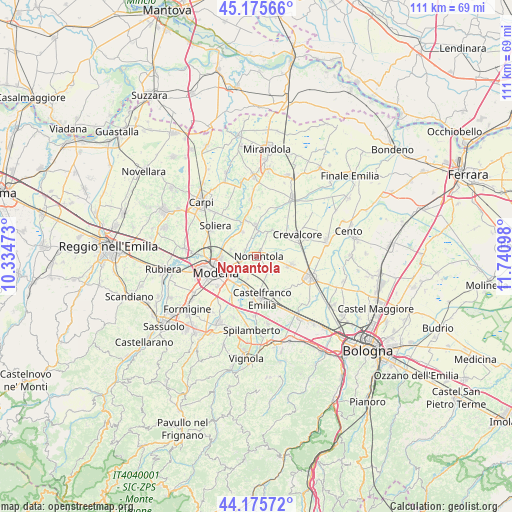
Nonantola GPS coordinates[2]
44° 40' 40.26" North, 11° 2' 16.26" East
| Map corner | latitude | longitude |
|---|---|---|
| Upper-left | 45.17566°, | 10.33473° |
| Center: | 44.67785°, | 11.03785° |
| Lower-right: | 44.17572°, | 11.74098° |
| Map W x H: | 111.2×111.2 km | = 69.1×69.1mi |
| max Lat: | 47.04031° ⇑46.2% North |
| Nonantola: | 44.67785° |
| min Lat: | ⇓53.8% South 35.50142° |
| min Long | Nonantola | max Long |
| 6.69888° | 11.03785° | 18.48682° |
| W 43.3%⇐ | ⇒56.7% E |
Elevation
Elevation of Nonantola is 25 m = 82 ft, and this is 281.7 m = 924 ft below average elevation for this country.
| Max E: |
2085 m = 6841 ft | 87% |
| Avg. | 306.7 m = 1006 ft | |
| Nonantola | 25 m = 82 ft | |
Min E: |
-4 m = -13 ft | 13% |
See also: Italy elevation on elevation.city.
Geographical zone
Nonantola is located in North temperate zone (between Tropic of Cancer and the Arctic Circle). Distance of this Northern Tropic circle is 2361.8 km =1467.6 mi to South.| Distance of | km | miles | from Nonantola |
|---|---|---|---|
| North Pole | 5039.4 | 3131.3 | to North |
| Arctic Circle | 2433.5 | 1512.1 | to North |
| Tropic Cancer | 2361.8 | 1467.6 | to South |
| Equator | 4967.7 | 3086.8 | to South |


Nearby cities:
15 places around Nonantola: (largest is in red/bold)
• Albareto
5.7 km =3.5 mi,  283°
283°
• Bastiglia
6.3 km =3.9 mi,  330°
330°
• Bomporto
6.2 km =3.9 mi,  359°
359°
• Castelfranco Emilia
9.3 km =5.8 mi,  174°
174°
• Crevalcore
9.8 km =6.1 mi,  61°
61°
• Gaggio
5.2 km =3.2 mi,  201°
201°
• La Grande
4.9 km =3 mi,  24°
24°
• Modena
9.5 km =5.9 mi,  249°
249°
• Ravarino
6.9 km =4.3 mi,  41°
41°
• Sant'Agata Bolognese
7.8 km =4.8 mi,  104°
104°
• Sant'Anna
8.9 km =5.5 mi,  190°
190°
• Sorbara
8.2 km =5.1 mi,  342°
342°
• Sozzigalli
9.4 km =5.8 mi, 327°
• Via Larga
2.5 km =1.6 mi, 103°
• Villanova
9.6 km =6 mi, 277°
Sources, notices
• [Note1] Compared only with cities in Italy existing in our database
• [Src1] Map data: © OpenStreetMap contributors (CC-BY-SA)
• [Src2] Other city data from geonames.org with taken over terms of usage.
• [Src3] Geographical zone / Annual Mean Temperature by Robert A. Rohde @ Wikipedia
