Via Larga geodata
Via Larga (Emilia-Romagna) is a populated place; located in Italy in Europe/Rome (GMT+2) time zone. With population of 821 people, there are 7544 cities with bigger population in this country. Compared to other cities in Italy, 53.7% of cities are located further ↓South; 56.4% of cities are located further →East and 87% of cities have higher elevation than Via Larga. Note1


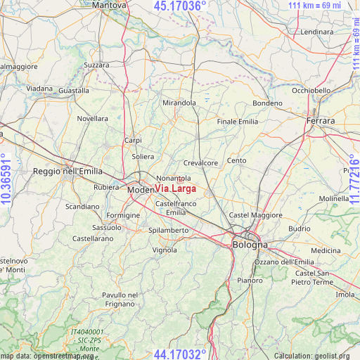
Via Larga GPS coordinates[2]
44° 40' 21" North, 11° 4' 8.508" East
| Map corner | latitude | longitude |
|---|---|---|
| Upper-left | 45.17036°, | 10.36591° |
| Center: | 44.6725°, | 11.06903° |
| Lower-right: | 44.17032°, | 11.77216° |
| Map W x H: | 111.2×111.2 km | = 69.1×69.1mi |
| max Lat: | 47.04031° ⇑46.3% North |
| Via Larga: | 44.6725° |
| min Lat: | ⇓53.7% South 35.50142° |
| min Long | Via Larga | max Long |
| 6.69888° | 11.06903° | 18.48682° |
| W 43.6%⇐ | ⇒56.4% E |
Elevation
Elevation of Via Larga is 25 m = 82 ft, and this is 281.7 m = 924 ft below average elevation for this country.
| Max E: |
2085 m = 6841 ft | 87% |
| Avg. | 306.7 m = 1006 ft | |
| Via Larga | 25 m = 82 ft | |
Min E: |
-4 m = -13 ft | 13% |
See also: Italy elevation on elevation.city.
Geographical zone
Via Larga is located in North temperate zone (between Tropic of Cancer and the Arctic Circle). Distance of this Northern Tropic circle is 2361.2 km =1467.2 mi to South.| Distance of | km | miles | from Via Larga |
|---|---|---|---|
| North Pole | 5039.9 | 3131.6 | to North |
| Arctic Circle | 2434.1 | 1512.5 | to North |
| Tropic Cancer | 2361.2 | 1467.2 | to South |
| Equator | 4967.1 | 3086.4 | to South |


Nearby cities:
15 places around Via Larga: (largest is in red/bold)
• Albareto
8.3 km =5.2 mi,  283°
283°
• Bastiglia
8.2 km =5.1 mi,  317°
317°
• Bomporto
7.3 km =4.5 mi,  339°
339°
• Castelfranco Emilia
8.8 km =5.5 mi,  189°
189°
• Crevalcore
8.1 km =5 mi,  49°
49°
• Gaggio
6.1 km =3.8 mi,  226°
226°
• Gorghetto
10.9 km =6.8 mi,  1°
1°
• La Grande
5.1 km =3.2 mi,  354°
354°
• Manzolino
8.9 km =5.5 mi,  164°
164°
• Nonantola
2.5 km =1.6 mi, 283°
• Ravarino
6.2 km =3.9 mi,  20°
20°
• San Giovanni in Persiceto
9.9 km =6.2 mi,  112°
112°
• Sant'Agata Bolognese
5.2 km =3.2 mi, 105°
• Sant'Anna
9.2 km =5.7 mi,  206°
206°
• Sorbara
9.7 km =6 mi,  329°
329°
Sources, notices
• [Note1] Compared only with cities in Italy existing in our database
• [Src1] Map data: © OpenStreetMap contributors (CC-BY-SA)
• [Src2] Other city data from geonames.org with taken over terms of usage.
• [Src3] Geographical zone / Annual Mean Temperature by Robert A. Rohde @ Wikipedia
