Villanova geodata
Villanova (Emilia-Romagna) is a populated place; located in Italy in Europe/Rome (GMT+2) time zone. With population of 1,331 people, there are 5542 cities with bigger population in this country. Compared to other cities in Italy, 54% of cities are located further ↓South; 58.3% of cities are located further →East and 84.4% of cities have higher elevation than Villanova. Note1


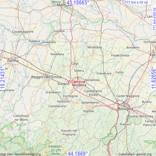
Villanova GPS coordinates[2]
44° 41' 20.148" North, 10° 55' 2.748" East
| Map corner | latitude | longitude |
|---|---|---|
| Upper-left | 45.18665°, | 10.21431° |
| Center: | 44.68893°, | 10.91743° |
| Lower-right: | 44.1869°, | 11.62056° |
| Map W x H: | 111.2×111.2 km | = 69.1×69.1mi |
| max Lat: | 47.04031° ⇑46% North |
| Villanova: | 44.68893° |
| min Lat: | ⇓54% South 35.50142° |
| min Long | Villanova | max Long |
| 6.69888° | 10.91743° | 18.48682° |
| W 41.7%⇐ | ⇒58.3% E |
Elevation
Elevation of Villanova is 33 m = 108 ft, and this is 273.7 m = 898 ft below average elevation for this country.
| Max E: |
2085 m = 6841 ft | 84.4% |
| Avg. | 306.7 m = 1006 ft | |
| Villanova | 33 m = 108 ft | |
Min E: |
-4 m = -13 ft | 15.6% |
See also: Italy elevation on elevation.city.
Geographical zone
Villanova is located in North temperate zone (between Tropic of Cancer and the Arctic Circle). Distance of this Northern Tropic circle is 2363 km =1468.3 mi to South.| Distance of | km | miles | from Villanova |
|---|---|---|---|
| North Pole | 5038.1 | 3130.5 | to North |
| Arctic Circle | 2432.2 | 1511.3 | to North |
| Tropic Cancer | 2363 | 1468.3 | to South |
| Equator | 4968.9 | 3087.5 | to South |


Nearby cities:
15 places around Villanova: (largest is in red/bold)
• Albareto
3.9 km =2.4 mi,  88°
88°
• Baggiovara
10.4 km =6.5 mi,  204°
204°
• Bastiglia
7.7 km =4.8 mi,  56°
56°
• Campogalliano
5.6 km =3.5 mi,  269°
269°
• Fontana
9.2 km =5.7 mi,  262°
262°
• Gaggio
9.7 km =6 mi,  128°
128°
• Gargallo
7.4 km =4.6 mi,  323°
323°
• Lesignana
2 km =1.2 mi, 256°
• Limidi
8.4 km =5.2 mi,  1°
1°
• Modena
4.6 km =2.9 mi,  172°
172°
• Nonantola
9.6 km =6 mi,  97°
97°
• Santa Croce Scuole
9.8 km =6.1 mi,  326°
326°
• Soliera
5 km =3.1 mi, 3°
• Sorbara
9.7 km =6 mi,  47°
47°
• Sozzigalli
8.1 km =5 mi,  33°
33°
Sources, notices
• [Note1] Compared only with cities in Italy existing in our database
• [Src1] Map data: © OpenStreetMap contributors (CC-BY-SA)
• [Src2] Other city data from geonames.org with taken over terms of usage.
• [Src3] Geographical zone / Annual Mean Temperature by Robert A. Rohde @ Wikipedia
