Barzanò geodata
Barzanò (Lombardy) is a seat of a third-order administrative division; located in Italy in Europe/Rome (GMT+2) time zone. With population of 5,120 people, there are 1914 cities with bigger population in this country. Compared to other cities in Italy, 82.7% of cities are located further ↓South; 76.1% of cities are located further →East and 67.7% of cities have lower elevation than Barzanò. Note1


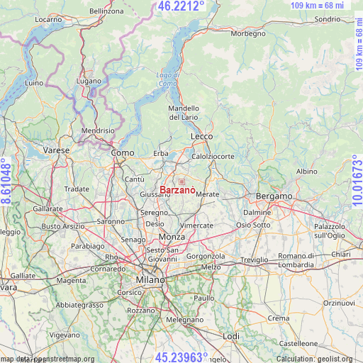
Barzanò GPS coordinates[2]
45° 43' 57.252" North, 9° 18' 48.96" East
| Map corner | latitude | longitude |
|---|---|---|
| Upper-left | 46.2212°, | 8.61048° |
| Center: | 45.73257°, | 9.3136° |
| Lower-right: | 45.23963°, | 10.01673° |
| Map W x H: | 109.1×109.1 km | = 67.8×67.8mi |
| max Lat: | 47.04031° ⇑17.3% North |
| Barzanò: | 45.73257° |
| min Lat: | ⇓82.7% South 35.50142° |
| min Long | Barzanò | max Long |
| 6.69888° | 9.3136° | 18.48682° |
| W 23.9%⇐ | ⇒76.1% E |
Elevation
Elevation of Barzanò is 370 m = 1214 ft, and this is 63.3 m = 208 ft above average elevation for this country.
| Max E: |
2085 m = 6841 ft | 32.3% |
| Barzanò | 370 m 1214 ft | |
| Avg. | 306.7 m = 1006 ft | |
Min E: |
-4 m = -13 ft | 67.7% |
See also: Italy elevation on elevation.city.
Geographical zone
Barzanò is located in North temperate zone (between Tropic of Cancer and the Arctic Circle). Distance of this North polar circle is 2316.2 km =1439.2 mi to North.| Distance of | km | miles | from Barzanò |
|---|---|---|---|
| North Pole | 4922.1 | 3058.5 | to North |
| Arctic Circle | 2316.2 | 1439.2 | to North |
| Tropic Cancer | 2479.1 | 1540.4 | to South |
| Equator | 5085 | 3159.7 | to South |


Nearby cities:
15 places around Barzanò: (largest is in red/bold)
• Barzago
2.5 km =1.6 mi,  1°
1°
• Besana in Brianza
3.7 km =2.3 mi,  203°
203°
• Brongio
3.6 km =2.2 mi,  358°
358°
• Bulciago
3 km =1.9 mi,  312°
312°
• Cassago Brianza
1.7 km =1.1 mi,  291°
291°
• Cologna-Caraverio
3.6 km =2.2 mi,  43°
43°
• Cortenuova
2.3 km =1.4 mi,  212°
212°
• Cremella
1.2 km =0.7 mi,  303°
303°
• Missaglia
3.3 km =2.1 mi,  150°
150°
• Monticello
2.2 km =1.4 mi,  177°
177°
• Monticello Brianza
2.6 km =1.6 mi, 176°
• Renate
2.8 km =1.7 mi,  250°
250°
• Sirtori
1.4 km =0.9 mi,  71°
71°
• Veduggio Con Colzano
3.4 km =2.1 mi,  272°
272°
• Viganò
1.2 km =0.7 mi,  134°
134°
Sources, notices
• [Note1] Compared only with cities in Italy existing in our database
• [Src1] Map data: © OpenStreetMap contributors (CC-BY-SA)
• [Src2] Other city data from geonames.org with taken over terms of usage.
• [Src3] Geographical zone / Annual Mean Temperature by Robert A. Rohde @ Wikipedia
