Monticello geodata
Monticello (Lombardy) is a seat of a third-order administrative division; located in Italy in Europe/Rome (GMT+2) time zone. With population of 3,072 people, there are 2981 cities with bigger population in this country. Compared to other cities in Italy, 81.8% of cities are located further ↓South; 76% of cities are located further →East and 67.9% of cities have lower elevation than Monticello. Note1
Administrative division(s):
- Level 1: Lombardy
- Level 2: Provincia di Lecco
- Level 3: Monticello Brianza


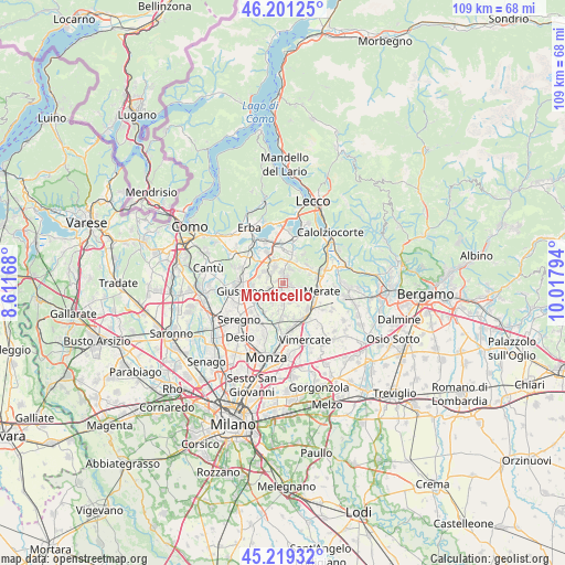
Monticello GPS coordinates[2]
45° 42' 44.784" North, 9° 18' 53.316" East
| Map corner | latitude | longitude |
|---|---|---|
| Upper-left | 46.20125°, | 8.61168° |
| Center: | 45.71244°, | 9.31481° |
| Lower-right: | 45.21932°, | 10.01794° |
| Map W x H: | 109.2×109.2 km | = 67.9×67.9mi |
| max Lat: | 47.04031° ⇑18.2% North |
| Monticello: | 45.71244° |
| min Lat: | ⇓81.8% South 35.50142° |
| min Long | Monticello | max Long |
| 6.69888° | 9.31481° | 18.48682° |
| W 24%⇐ | ⇒76% E |
Elevation
Elevation of Monticello is 373 m = 1224 ft, and this is 66.3 m = 218 ft above average elevation for this country.
| Max E: |
2085 m = 6841 ft | 32.1% |
| Monticello | 373 m 1224 ft | |
| Avg. | 306.7 m = 1006 ft | |
Min E: |
-4 m = -13 ft | 67.9% |
See also: Italy elevation on elevation.city.
Geographical zone
Monticello is located in North temperate zone (between Tropic of Cancer and the Arctic Circle). Distance of this North polar circle is 2318.4 km =1440.6 mi to North.| Distance of | km | miles | from Monticello |
|---|---|---|---|
| North Pole | 4924.3 | 3059.8 | to North |
| Arctic Circle | 2318.4 | 1440.6 | to North |
| Tropic Cancer | 2476.8 | 1539 | to South |
| Equator | 5082.7 | 3158.2 | to South |


Nearby cities:
15 places around Monticello: (largest is in red/bold)
• Barzanò
2.2 km =1.4 mi,  357°
357°
• Besana in Brianza
1.9 km =1.2 mi,  234°
234°
• Casatenovo
1.9 km =1.2 mi,  183°
183°
• Cassago Brianza
3.3 km =2.1 mi,  329°
329°
• Cortenuova
1.4 km =0.9 mi,  284°
284°
• Cremella
3.1 km =1.9 mi,  339°
339°
• Lomaniga
3.5 km =2.2 mi,  107°
107°
• Maresso
4.2 km =2.6 mi,  130°
130°
• Missaglia
1.7 km =1.1 mi, 112°
• Monticello Brianza
0.3 km =0.2 mi,  168°
168°
• Renate
3 km =1.9 mi,  296°
296°
• Rogoredo-Valaperta-Rimoldo
4.2 km =2.6 mi,  160°
160°
• Sirtori
3 km =1.9 mi,  24°
24°
• Veduggio Con Colzano
4.2 km =2.6 mi, 304°
• Viganò
1.6 km =1 mi,  30°
30°
Sources, notices
• [Note1] Compared only with cities in Italy existing in our database
• [Src1] Map data: © OpenStreetMap contributors (CC-BY-SA)
• [Src2] Other city data from geonames.org with taken over terms of usage.
• [Src3] Geographical zone / Annual Mean Temperature by Robert A. Rohde @ Wikipedia
