Missaglia geodata
Missaglia (Lombardy) is a seat of a third-order administrative division; located in Italy in Europe/Rome (GMT+2) time zone. With population of 5,781 people, there are 1699 cities with bigger population in this country. Compared to other cities in Italy, 81.5% of cities are located further ↓South; 75.7% of cities are located further →East and 60.4% of cities have lower elevation than Missaglia. Note1


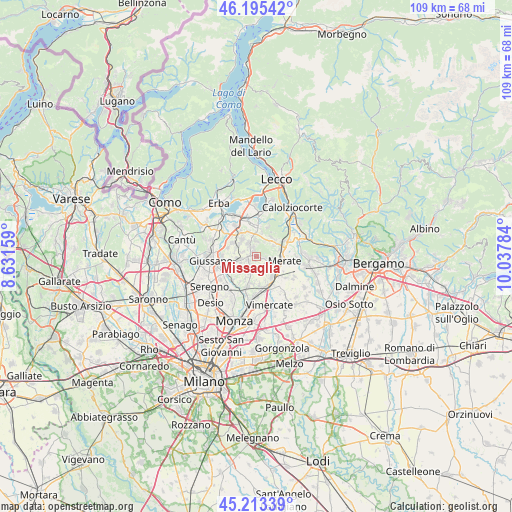
Missaglia GPS coordinates[2]
45° 42' 23.616" North, 9° 20' 4.956" East
| Map corner | latitude | longitude |
|---|---|---|
| Upper-left | 46.19542°, | 8.63159° |
| Center: | 45.70656°, | 9.33471° |
| Lower-right: | 45.21339°, | 10.03784° |
| Map W x H: | 109.2×109.2 km | = 67.9×67.9mi |
| max Lat: | 47.04031° ⇑18.5% North |
| Missaglia: | 45.70656° |
| min Lat: | ⇓81.5% South 35.50142° |
| min Long | Missaglia | max Long |
| 6.69888° | 9.33471° | 18.48682° |
| W 24.3%⇐ | ⇒75.7% E |
Elevation
Elevation of Missaglia is 302 m = 991 ft, and this is 4.7 m = 15 ft below average elevation for this country.
| Max E: |
2085 m = 6841 ft | 39.6% |
| Avg. | 306.7 m = 1006 ft | |
| Missaglia | 302 m = 991 ft | |
Min E: |
-4 m = -13 ft | 60.4% |
See also: Italy elevation on elevation.city.
Geographical zone
Missaglia is located in North temperate zone (between Tropic of Cancer and the Arctic Circle). Distance of this North polar circle is 2319.1 km =1441 mi to North.| Distance of | km | miles | from Missaglia |
|---|---|---|---|
| North Pole | 4925 | 3060.3 | to North |
| Arctic Circle | 2319.1 | 1441 | to North |
| Tropic Cancer | 2476.2 | 1538.6 | to South |
| Equator | 5082.1 | 3157.9 | to South |


Nearby cities:
15 places around Missaglia: (largest is in red/bold)
• Barzanò
3.3 km =2.1 mi,  330°
330°
• Besana in Brianza
3.1 km =1.9 mi,  261°
261°
• Casatenovo
2.1 km =1.3 mi,  232°
232°
• Cortenuova
3 km =1.9 mi,  289°
289°
• Lomaniga
1.8 km =1.1 mi,  101°
101°
• Maresso
2.7 km =1.7 mi,  142°
142°
• Montevecchia
3.6 km =2.2 mi,  91°
91°
• Monticello
1.7 km =1.1 mi, 292°
• Monticello Brianza
1.5 km =0.9 mi,  282°
282°
• Perego
4.1 km =2.5 mi,  32°
32°
• Quattro Strade
3.5 km =2.2 mi,  110°
110°
• Rogoredo-Valaperta-Rimoldo
3.3 km =2.1 mi,  182°
182°
• Rovagnate
4.4 km =2.7 mi,  39°
39°
• Sirtori
3.4 km =2.1 mi,  354°
354°
• Viganò
2.2 km =1.4 mi,  339°
339°
Sources, notices
• [Note1] Compared only with cities in Italy existing in our database
• [Src1] Map data: © OpenStreetMap contributors (CC-BY-SA)
• [Src2] Other city data from geonames.org with taken over terms of usage.
• [Src3] Geographical zone / Annual Mean Temperature by Robert A. Rohde @ Wikipedia
