Baranello geodata
Baranello (Molise) is a seat of a third-order administrative division; located in Italy in Europe/Rome (GMT+2) time zone. With population of 684 people, there are 8395 cities with bigger population in this country. Compared to other cities in Italy, 74.6% of cities are located further ↑North; 83.3% of cities are located further ←West and 85.3% of cities have lower elevation than Baranello. Note1


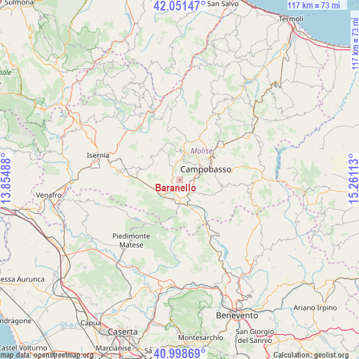
Baranello GPS coordinates[2]
41° 31' 37.992" North, 14° 33' 28.8" East
| Map corner | latitude | longitude |
|---|---|---|
| Upper-left | 42.05147°, | 13.85488° |
| Center: | 41.52722°, | 14.558° |
| Lower-right: | 40.99869°, | 15.26113° |
| Map W x H: | 117.1×117.1 km | = 72.8×72.8mi |
| max Lat: | 47.04031° ⇑74.6% North |
| Baranello: | 41.52722° |
| min Lat: | ⇓25.4% South 35.50142° |
| min Long | Baranello | max Long |
| 6.69888° | 14.558° | 18.48682° |
| W 83.3%⇐ | ⇒16.7% E |
Elevation
Elevation of Baranello is 619 m = 2031 ft, and this is 312.3 m = 1025 ft above average elevation for this country.
| Max E: |
2085 m = 6841 ft | 14.7% |
| Baranello | 619 m 2031 ft | |
| Avg. | 306.7 m = 1006 ft | |
Min E: |
-4 m = -13 ft | 85.3% |
See also: Italy elevation on elevation.city.
Geographical zone
Baranello is located in North temperate zone (between Tropic of Cancer and the Arctic Circle). Distance of this Northern Tropic circle is 2011.5 km =1249.9 mi to South.| Distance of | km | miles | from Baranello |
|---|---|---|---|
| North Pole | 5389.7 | 3349 | to North |
| Arctic Circle | 2783.8 | 1729.8 | to North |
| Tropic Cancer | 2011.5 | 1249.9 | to South |
| Equator | 4617.4 | 2869.1 | to South |


Nearby cities:
15 places around Baranello: (largest is in red/bold)
• Bojano
8.6 km =5.3 mi,  237°
237°
• Busso
3 km =1.9 mi,  4°
4°
• Campochiaro
9.7 km =6 mi,  205°
205°
• Casalciprano
6.4 km =4 mi,  337°
337°
• Colle d'Anchise
3.8 km =2.4 mi, 239°
• Ferrazzano
9.5 km =5.9 mi,  87°
87°
• Largo Zullo-Sterparo
2.9 km =1.8 mi,  107°
107°
• Mimosa-Poggio Verde-Nuova Comunità
9.3 km =5.8 mi,  82°
82°
• Mirabello Sannitico
9.7 km =6 mi,  97°
97°
• Monteverde
6.8 km =4.2 mi, 242°
• Oratino
7.2 km =4.5 mi,  25°
25°
• San Polomatese
9.3 km =5.8 mi,  215°
215°
• Sant'Elena Sannita
9 km =5.6 mi,  306°
306°
• Spinete
6.2 km =3.9 mi,  287°
287°
• Vinchiaturo
4.8 km =3 mi,  143°
143°
Sources, notices
• [Note1] Compared only with cities in Italy existing in our database
• [Src1] Map data: © OpenStreetMap contributors (CC-BY-SA)
• [Src2] Other city data from geonames.org with taken over terms of usage.
• [Src3] Geographical zone / Annual Mean Temperature by Robert A. Rohde @ Wikipedia
