Raviscanina geodata
Raviscanina (Campania) is a seat of a third-order administrative division; located in Italy in Europe/Rome (GMT+2) time zone. With population of 629 people, there are 8780 cities with bigger population in this country. Compared to other cities in Italy, 75.7% of cities are located further ↑North; 80.3% of cities are located further ←West and 66.3% of cities have lower elevation than Raviscanina. Note1


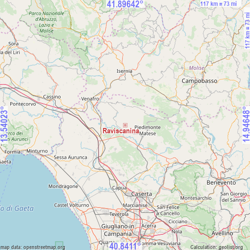
Raviscanina GPS coordinates[2]
41° 22' 15.24" North, 14° 14' 36.06" East
| Map corner | latitude | longitude |
|---|---|---|
| Upper-left | 41.89642°, | 13.54023° |
| Center: | 41.3709°, | 14.24335° |
| Lower-right: | 40.8411°, | 14.94648° |
| Map W x H: | 117.3×117.3 km | = 72.9×72.9mi |
| max Lat: | 47.04031° ⇑75.7% North |
| Raviscanina: | 41.3709° |
| min Lat: | ⇓24.3% South 35.50142° |
| min Long | Raviscanina | max Long |
| 6.69888° | 14.24335° | 18.48682° |
| W 80.3%⇐ | ⇒19.7% E |
Elevation
Elevation of Raviscanina is 356 m = 1168 ft, and this is 49.3 m = 162 ft above average elevation for this country.
| Max E: |
2085 m = 6841 ft | 33.7% |
| Raviscanina | 356 m 1168 ft | |
| Avg. | 306.7 m = 1006 ft | |
Min E: |
-4 m = -13 ft | 66.3% |
See also: Italy elevation on elevation.city.
Geographical zone
Raviscanina is located in North temperate zone (between Tropic of Cancer and the Arctic Circle). Distance of this Northern Tropic circle is 1994.1 km =1239.1 mi to South.| Distance of | km | miles | from Raviscanina |
|---|---|---|---|
| North Pole | 5407 | 3359.8 | to North |
| Arctic Circle | 2801.2 | 1740.6 | to North |
| Tropic Cancer | 1994.1 | 1239.1 | to South |
| Equator | 4600 | 2858.3 | to South |


Nearby cities:
15 places around Raviscanina: (largest is in red/bold)
• Ailano
3.8 km =2.4 mi,  303°
303°
• Alife
9.1 km =5.7 mi,  123°
123°
• Baia
7.5 km =4.7 mi,  175°
175°
• Fontegreca
10.7 km =6.6 mi,  332°
332°
• Gallo
10.6 km =6.6 mi,  351°
351°
• Gallo Matese
10.5 km =6.5 mi, 351°
• Latina
9.3 km =5.8 mi,  164°
164°
• Letino
9.2 km =5.7 mi,  6°
6°
• Piedimonte Matese
10.6 km =6.6 mi,  102°
102°
• Pietravairano
8.2 km =5.1 mi,  231°
231°
• Prata Sannita Centro
7.7 km =4.8 mi, 333°
• Pratella
6.6 km =4.1 mi,  305°
305°
• Sant'Angelo d'Alife
1.8 km =1.1 mi,  125°
125°
• Vairano-Patenora
10.1 km =6.3 mi,  248°
248°
• Valle Agricola
6.1 km =3.8 mi, 9°
Sources, notices
• [Note1] Compared only with cities in Italy existing in our database
• [Src1] Map data: © OpenStreetMap contributors (CC-BY-SA)
• [Src2] Other city data from geonames.org with taken over terms of usage.
• [Src3] Geographical zone / Annual Mean Temperature by Robert A. Rohde @ Wikipedia
