Avellino geodata
Avellino (Campania) is a seat of a second-order administrative division; located in Italy in Europe/Rome (GMT+2) time zone. With population of 48,104 people, there are 125 cities with bigger population in this country. Compared to other cities in Italy, 79.7% of cities are located further ↑North; 85.4% of cities are located further ←West and 66.7% of cities have lower elevation than Avellino. Note1


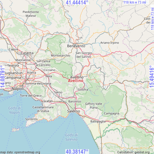
Avellino GPS coordinates[2]
40° 54' 53.784" North, 14° 47' 27.708" East
| Map corner | latitude | longitude |
|---|---|---|
| Upper-left | 41.44414°, | 14.08791° |
| Center: | 40.91494°, | 14.79103° |
| Lower-right: | 40.38147°, | 15.49416° |
| Map W x H: | 118.2×118.2 km | = 73.4×73.4mi |
| max Lat: | 47.04031° ⇑79.7% North |
| Avellino: | 40.91494° |
| min Lat: | ⇓20.3% South 35.50142° |
| min Long | Avellino | max Long |
| 6.69888° | 14.79103° | 18.48682° |
| W 85.4%⇐ | ⇒14.6% E |
Elevation
Elevation of Avellino is 360 m = 1181 ft, and this is 53.3 m = 175 ft above average elevation for this country.
| Max E: |
2085 m = 6841 ft | 33.3% |
| Avellino | 360 m 1181 ft | |
| Avg. | 306.7 m = 1006 ft | |
Min E: |
-4 m = -13 ft | 66.7% |
See also: Avellino elevation on elevation.city.
Geographical zone
Avellino is located in North temperate zone (between Tropic of Cancer and the Arctic Circle). Distance of this Northern Tropic circle is 1943.4 km =1207.6 mi to South.| Distance of | km | miles | from Avellino |
|---|---|---|---|
| North Pole | 5457.7 | 3391.3 | to North |
| Arctic Circle | 2851.9 | 1772.1 | to North |
| Tropic Cancer | 1943.4 | 1207.6 | to South |
| Equator | 4549.3 | 2826.8 | to South |


Nearby cities:
15 places around Avellino: (largest is in red/bold)
• Aiello del Sabato
3.9 km =2.4 mi,  139°
139°
• Alvanite
3.1 km =1.9 mi,  105°
105°
• Atripalda
3.1 km =1.9 mi,  82°
82°
• Bellizzi Irpino
2.8 km =1.7 mi,  167°
167°
• Capriglia
5.1 km =3.2 mi,  347°
347°
• Capriglia Irpina
5.2 km =3.2 mi, 347°
• Cesinali
3.7 km =2.3 mi,  122°
122°
• Contrada
5.3 km =3.3 mi,  192°
192°
• Mercogliano
3.9 km =2.4 mi,  280°
280°
• Molinelle
2.8 km =1.7 mi,  241°
241°
• Monteforte Irpino
4.2 km =2.6 mi,  250°
250°
• Montefredane
5.3 km =3.3 mi,  20°
20°
• Ospedaletto d'Alpinolo
4.6 km =2.9 mi,  305°
305°
• Sabina
2.9 km =1.8 mi, 120°
• Torelli-Torrette
3.4 km =2.1 mi,  256°
256°
Sources, notices
• [Note1] Compared only with cities in Italy existing in our database
• [Src1] Map data: © OpenStreetMap contributors (CC-BY-SA)
• [Src2] Other city data from geonames.org with taken over terms of usage.
• [Src3] Geographical zone / Annual Mean Temperature by Robert A. Rohde @ Wikipedia
