Mercogliano geodata
Mercogliano (Campania) is a seat of a third-order administrative division; located in Italy in Europe/Rome (GMT+2) time zone. With population of 7,392 people, there are 1317 cities with bigger population in this country. Compared to other cities in Italy, 79.6% of cities are located further ↑North; 84.9% of cities are located further ←West and 77.3% of cities have lower elevation than Mercogliano. Note1


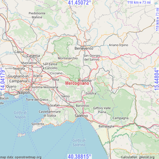
Mercogliano GPS coordinates[2]
40° 55' 17.652" North, 14° 44' 41.676" East
| Map corner | latitude | longitude |
|---|---|---|
| Upper-left | 41.45072°, | 14.04179° |
| Center: | 40.92157°, | 14.74491° |
| Lower-right: | 40.38815°, | 15.44804° |
| Map W x H: | 118.1×118.1 km | = 73.4×73.4mi |
| max Lat: | 47.04031° ⇑79.6% North |
| Mercogliano: | 40.92157° |
| min Lat: | ⇓20.4% South 35.50142° |
| min Long | Mercogliano | max Long |
| 6.69888° | 14.74491° | 18.48682° |
| W 84.9%⇐ | ⇒15.1% E |
Elevation
Elevation of Mercogliano is 484 m = 1588 ft, and this is 177.3 m = 582 ft above average elevation for this country.
| Max E: |
2085 m = 6841 ft | 22.7% |
| Mercogliano | 484 m 1588 ft | |
| Avg. | 306.7 m = 1006 ft | |
Min E: |
-4 m = -13 ft | 77.3% |
See also: Italy elevation on elevation.city.
Geographical zone
Mercogliano is located in North temperate zone (between Tropic of Cancer and the Arctic Circle). Distance of this Northern Tropic circle is 1944.1 km =1208 mi to South.| Distance of | km | miles | from Mercogliano |
|---|---|---|---|
| North Pole | 5457 | 3390.8 | to North |
| Arctic Circle | 2851.1 | 1771.6 | to North |
| Tropic Cancer | 1944.1 | 1208 | to South |
| Equator | 4550.1 | 2827.3 | to South |


Nearby cities:
15 places around Mercogliano: (largest is in red/bold)
• Atripalda
6.9 km =4.3 mi,  92°
92°
• Avellino
3.9 km =2.4 mi,  100°
100°
• Bellizzi Irpino
5.7 km =3.5 mi,  127°
127°
• Capriglia
5.1 km =3.2 mi,  33°
33°
• Capriglia Irpina
5.1 km =3.2 mi, 32°
• Contrada
6.5 km =4 mi,  155°
155°
• Grottolella
6.7 km =4.2 mi, 33°
• Molinelle
2.5 km =1.6 mi,  145°
145°
• Monteforte Irpino
2.1 km =1.3 mi,  182°
182°
• Ospedaletto d'Alpinolo
1.9 km =1.2 mi,  3°
3°
• Petruro
6.1 km =3.8 mi,  173°
173°
• Sabina
6.8 km =4.2 mi,  109°
109°
• Sant'Angelo A Scala
5.9 km =3.7 mi,  356°
356°
• Summonte
3 km =1.9 mi, 359°
• Torelli-Torrette
1.6 km =1 mi, 159°
Sources, notices
• [Note1] Compared only with cities in Italy existing in our database
• [Src1] Map data: © OpenStreetMap contributors (CC-BY-SA)
• [Src2] Other city data from geonames.org with taken over terms of usage.
• [Src3] Geographical zone / Annual Mean Temperature by Robert A. Rohde @ Wikipedia
