Ascea geodata
Ascea (Campania) is a seat of a third-order administrative division; located in Italy in Europe/Rome (GMT+2) time zone. With population of 1,199 people, there are 5960 cities with bigger population in this country. Compared to other cities in Italy, 86.8% of cities are located further ↑North; 88.7% of cities are located further ←West and 50.6% of cities have higher elevation than Ascea. Note1


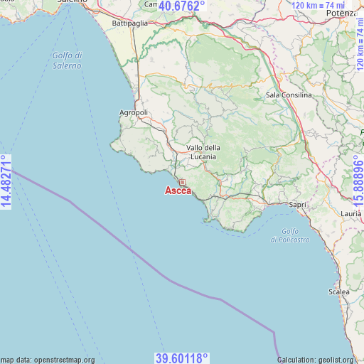
Ascea GPS coordinates[2]
40° 8' 26.952" North, 15° 11' 8.988" East
| Map corner | latitude | longitude |
|---|---|---|
| Upper-left | 40.6762°, | 14.48271° |
| Center: | 40.14082°, | 15.18583° |
| Lower-right: | 39.60118°, | 15.88896° |
| Map W x H: | 119.5×119.5 km | = 74.3×74.3mi |
| max Lat: | 47.04031° ⇑86.8% North |
| Ascea: | 40.14082° |
| min Lat: | ⇓13.2% South 35.50142° |
| min Long | Ascea | max Long |
| 6.69888° | 15.18583° | 18.48682° |
| W 88.7%⇐ | ⇒11.3% E |
Elevation
Elevation of Ascea is 231 m = 758 ft, and this is 75.7 m = 248 ft below average elevation for this country.
| Max E: |
2085 m = 6841 ft | 50.6% |
| Avg. | 306.7 m = 1006 ft | |
| Ascea | 231 m = 758 ft | |
Min E: |
-4 m = -13 ft | 49.4% |
See also: Italy elevation on elevation.city.
Geographical zone
Ascea is located in North temperate zone (between Tropic of Cancer and the Arctic Circle). Distance of this Northern Tropic circle is 1857.3 km =1154.1 mi to South.| Distance of | km | miles | from Ascea |
|---|---|---|---|
| North Pole | 5543.8 | 3444.8 | to North |
| Arctic Circle | 2937.9 | 1825.5 | to North |
| Tropic Cancer | 1857.3 | 1154.1 | to South |
| Equator | 4463.2 | 2773.3 | to South |


Nearby cities:
15 places around Ascea: (largest is in red/bold)
• Acquavella
9.5 km =5.9 mi,  322°
322°
• Bivio Acquavella-Ponte
7.6 km =4.7 mi,  332°
332°
• Casal Velino
8.4 km =5.2 mi,  311°
311°
• Castelnuovo Cilento
8.7 km =5.4 mi,  355°
355°
• Ceraso
8.4 km =5.2 mi,  45°
45°
• Cuccaro Vetere
10.6 km =6.6 mi,  75°
75°
• Futani
11.8 km =7.3 mi, 84°
• Marina di Casal Velino
6.7 km =4.2 mi, 306°
• Pisciotta
5.5 km =3.4 mi,  130°
130°
• Salento
12 km =7.5 mi,  1°
1°
• Salicuneta
6.6 km =4.1 mi,  351°
351°
• San Mauro la Bruca
9.2 km =5.7 mi,  102°
102°
• Santa Barbara
7.4 km =4.6 mi,  55°
55°
• Vallo della Lucania
11.9 km =7.4 mi,  35°
35°
• Velina
7.2 km =4.5 mi,  342°
342°
Sources, notices
• [Note1] Compared only with cities in Italy existing in our database
• [Src1] Map data: © OpenStreetMap contributors (CC-BY-SA)
• [Src2] Other city data from geonames.org with taken over terms of usage.
• [Src3] Geographical zone / Annual Mean Temperature by Robert A. Rohde @ Wikipedia
