Brogliano geodata
Brogliano (Veneto) is a seat of a third-order administrative division; located in Italy in Europe/Rome (GMT+2) time zone. With population of 2,562 people, there are 3450 cities with bigger population in this country. Compared to other cities in Italy, 76.6% of cities are located further ↓South; 52.3% of cities are located further →East and 58.8% of cities have higher elevation than Brogliano. Note1


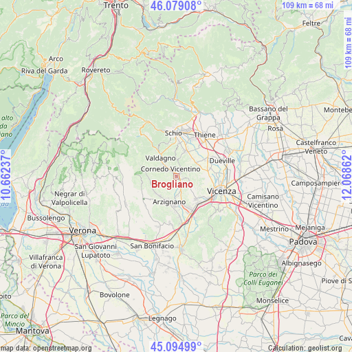
Brogliano GPS coordinates[2]
45° 35' 21.084" North, 11° 21' 55.764" East
| Map corner | latitude | longitude |
|---|---|---|
| Upper-left | 46.07908°, | 10.66237° |
| Center: | 45.58919°, | 11.36549° |
| Lower-right: | 45.09499°, | 12.06862° |
| Map W x H: | 109.4×109.4 km | = 68×68mi |
| max Lat: | 47.04031° ⇑23.4% North |
| Brogliano: | 45.58919° |
| min Lat: | ⇓76.6% South 35.50142° |
| min Long | Brogliano | max Long |
| 6.69888° | 11.36549° | 18.48682° |
| W 47.7%⇐ | ⇒52.3% E |
Elevation
Elevation of Brogliano is 173 m = 568 ft, and this is 133.7 m = 439 ft below average elevation for this country.
| Max E: |
2085 m = 6841 ft | 58.8% |
| Avg. | 306.7 m = 1006 ft | |
| Brogliano | 173 m = 568 ft | |
Min E: |
-4 m = -13 ft | 41.2% |
See also: Italy elevation on elevation.city.
Geographical zone
Brogliano is located in North temperate zone (between Tropic of Cancer and the Arctic Circle). Distance of this North polar circle is 2332.1 km =1449.1 mi to North.| Distance of | km | miles | from Brogliano |
|---|---|---|---|
| North Pole | 4938 | 3068.3 | to North |
| Arctic Circle | 2332.1 | 1449.1 | to North |
| Tropic Cancer | 2463.1 | 1530.5 | to South |
| Equator | 5069 | 3149.7 | to South |


Nearby cities:
15 places around Brogliano: (largest is in red/bold)
• Arzignano
8 km =5 mi,  197°
197°
• Castelgomberto
2 km =1.2 mi,  110°
110°
• Castelnovo
7.9 km =4.9 mi,  68°
68°
• Cereda-Cozza Cornedo
1.4 km =0.9 mi,  6°
6°
• Chiampo
7.9 km =4.9 mi,  234°
234°
• Cornedo Vicentino
4 km =2.5 mi,  319°
319°
• Gambugliano
5.7 km =3.5 mi,  91°
91°
• Isola Vicentina
7.7 km =4.8 mi,  54°
54°
• Monte di Malo
7.9 km =4.9 mi,  357°
357°
• Monteviale
7.9 km =4.9 mi,  115°
115°
• Nogarole Vicentino
6.8 km =4.2 mi,  241°
241°
• Tezze
6.1 km =3.8 mi,  176°
176°
• Trissino
3.4 km =2.1 mi,  164°
164°
• Valdagno
8.1 km =5 mi, 320°
• Valle
3.6 km =2.2 mi, 94°
Sources, notices
• [Note1] Compared only with cities in Italy existing in our database
• [Src1] Map data: © OpenStreetMap contributors (CC-BY-SA)
• [Src2] Other city data from geonames.org with taken over terms of usage.
• [Src3] Geographical zone / Annual Mean Temperature by Robert A. Rohde @ Wikipedia
