Olbia geodata
Olbia (Sardinia) is a seat of a third-order administrative division; located in Italy in Europe/Rome (GMT+2) time zone. With population of 42,930 people, there are 163 cities with bigger population in this country. Compared to other cities in Italy, 79.6% of cities are located further ↑North; 73.3% of cities are located further →East and 93.6% of cities have higher elevation than Olbia. Note1


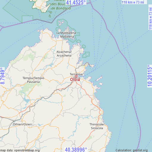
Olbia GPS coordinates[2]
40° 55' 24.132" North, 9° 29' 52.872" East
| Map corner | latitude | longitude |
|---|---|---|
| Upper-left | 41.4525°, | 8.7949° |
| Center: | 40.92337°, | 9.49802° |
| Lower-right: | 40.38996°, | 10.20115° |
| Map W x H: | 118.1×118.1 km | = 73.4×73.4mi |
| max Lat: | 47.04031° ⇑79.6% North |
| Olbia: | 40.92337° |
| min Lat: | ⇓20.4% South 35.50142° |
| min Long | Olbia | max Long |
| 6.69888° | 9.49802° | 18.48682° |
| W 26.7%⇐ | ⇒73.3% E |
Elevation
Elevation of Olbia is 11 m = 36 ft, and this is 295.7 m = 970 ft below average elevation for this country.
| Max E: |
2085 m = 6841 ft | 93.6% |
| Avg. | 306.7 m = 1006 ft | |
| Olbia | 11 m = 36 ft | |
Min E: |
-4 m = -13 ft | 6.4% |
See also: Olbia elevation on elevation.city.
Geographical zone
Olbia is located in North temperate zone (between Tropic of Cancer and the Arctic Circle). Distance of this Northern Tropic circle is 1944.3 km =1208.1 mi to South.| Distance of | km | miles | from Olbia |
|---|---|---|---|
| North Pole | 5456.8 | 3390.7 | to North |
| Arctic Circle | 2850.9 | 1771.5 | to North |
| Tropic Cancer | 1944.3 | 1208.1 | to South |
| Equator | 4550.3 | 2827.4 | to South |


Nearby cities:
15 places around Olbia: (largest is in red/bold)
• Arzachena
19.2 km =11.9 mi,  332°
332°
• Berchiddeddu
11.6 km =7.2 mi,  194°
194°
• Cannigione
21.8 km =13.5 mi,  346°
346°
• Golfo Aranci
13.2 km =8.2 mi,  59°
59°
• Golfo Aranci
13.5 km =8.4 mi,  46°
46°
• Loiri Porto San Paolo
9 km =5.6 mi,  179°
179°
• Monti
19.4 km =12.1 mi,  228°
228°
• Murta Maria
8.4 km =5.2 mi,  115°
115°
• Padru
17.6 km =10.9 mi,  173°
173°
• Pittulongu
6.6 km =4.1 mi,  65°
65°
• Porto San Paolo
12.1 km =7.5 mi, 116°
• San Pantaleo
13.8 km =8.6 mi, 349°
• San Teodoro
22 km =13.7 mi,  139°
139°
• Sant'Antonio di Gallura
18.2 km =11.3 mi,  294°
294°
• Telti
13.3 km =8.3 mi,  246°
246°
Sources, notices
• [Note1] Compared only with cities in Italy existing in our database
• [Src1] Map data: © OpenStreetMap contributors (CC-BY-SA)
• [Src2] Other city data from geonames.org with taken over terms of usage.
• [Src3] Geographical zone / Annual Mean Temperature by Robert A. Rohde @ Wikipedia
